Kronoby geodata
Kronoby (Ostrobothnia) is a seat of a third-order administrative division; located in Finland in Europe/Helsinki (GMT+3) time zone. With population of 6,813 people, there are 162 cities with bigger population in this country. Compared to other cities in Finland, 82.5% of cities are located further ↓South; 75% of cities are located further →East and 90.6% of cities have higher elevation than Kronoby. Note1


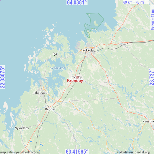
Kronoby GPS coordinates[2]
63° 43' 42.924" North, 23° 2' 1.932" East
| Map corner | latitude | longitude |
|---|---|---|
| Upper-left | 64.0381°, | 22.33075° |
| Center: | 63.72859°, | 23.03387° |
| Lower-right: | 63.41565°, | 23.737° |
| Map W x H: | 69.2×69.2 km | = 43×43mi |
| max Lat: | 69.90864° ⇑17.5% North |
| Kronoby: | 63.72859° |
| min Lat: | ⇓82.5% South 59.83333° |
| min Long | Kronoby | max Long |
| 21.2° | 23.03387° | 30.93276° |
| W 25%⇐ | ⇒75% E |
Elevation
Elevation of Kronoby is 12 m = 39 ft, and this is 65.1 m = 214 ft below average elevation for this country.
| Max E: |
299 m = 981 ft | 90.6% |
| Avg. | 77.1 m = 253 ft | |
| Kronoby | 12 m = 39 ft | |
Min E: |
1 m = 3 ft | 9.4% |
See also: Finland elevation on elevation.city.
Geographical zone
Kronoby is located in North temperate zone (between Tropic of Cancer and the Arctic Circle). Distance of this North polar circle is 315.2 km =195.9 mi to North.| Distance of | km | miles | from Kronoby |
|---|---|---|---|
| North Pole | 2921.1 | 1815.1 | to North |
| Arctic Circle | 315.2 | 195.9 | to North |
| Tropic Cancer | 4480 | 2783.7 | to South |
| Equator | 7086 | 4403 | to South |


Nearby cities:
15 places around Kronoby: (largest is in red/bold)
• Bennäs
18.4 km =11.4 mi,  218°
218°
• Evijärvi
46 km =28.6 mi,  151°
151°
• Himanka
47.9 km =29.8 mi,  39°
39°
• Jakobstad
17.4 km =10.8 mi,  249°
249°
• Kannus
46.6 km =29 mi,  65°
65°
• Kaustinen
38 km =23.6 mi,  121°
121°
• Kokkola
13.1 km =8.1 mi,  21°
21°
• Kortesjärvi
48.1 km =29.9 mi,  172°
172°
• Kälviä
25.3 km =15.7 mi,  54°
54°
• Larsmo
14.4 km =8.9 mi,  281°
281°
• Lohtaja
40.2 km =25 mi, 35°
• Nykarleby
33.8 km =21 mi,  227°
227°
• Pedersöre
19.4 km =12.1 mi,  243°
243°
• Ullava
53.7 km =33.4 mi,  105°
105°
• Veteli
46.3 km =28.8 mi,  126°
126°
Sources, notices
• [Note1] Compared only with cities in Finland existing in our database
• [Src1] Map data: © OpenStreetMap contributors (CC-BY-SA)
• [Src2] Other city data from geonames.org with taken over terms of usage.
• [Src3] Geographical zone / Annual Mean Temperature by Robert A. Rohde @ Wikipedia
