Kälviä geodata
Kälviä (Central Ostrobothnia) is a populated place; located in Finland in Europe/Helsinki (GMT+3) time zone. With population of 4,449 people, there are 231 cities with bigger population in this country. Compared to other cities in Finland, 83.8% of cities are located further ↓South; 70.7% of cities are located further →East and 75.9% of cities have higher elevation than Kälviä. Note1


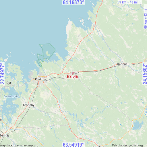
Kälviä GPS coordinates[2]
63° 51' 38.412" North, 23° 27' 10.404" East
| Map corner | latitude | longitude |
|---|---|---|
| Upper-left | 64.16873°, | 22.74977° |
| Center: | 63.86067°, | 23.45289° |
| Lower-right: | 63.54919°, | 24.15602° |
| Map W x H: | 68.9×68.9 km | = 42.8×42.8mi |
| max Lat: | 69.90864° ⇑16.2% North |
| Kälviä: | 63.86067° |
| min Lat: | ⇓83.8% South 59.83333° |
| min Long | Kälviä | max Long |
| 21.2° | 23.45289° | 30.93276° |
| W 29.3%⇐ | ⇒70.7% E |
Elevation
Elevation of Kälviä is 27 m = 89 ft, and this is 50.1 m = 164 ft below average elevation for this country.
| Max E: |
299 m = 981 ft | 75.9% |
| Avg. | 77.1 m = 253 ft | |
| Kälviä | 27 m = 89 ft | |
Min E: |
1 m = 3 ft | 24.1% |
See also: Finland elevation on elevation.city.
Geographical zone
Kälviä is located in North temperate zone (between Tropic of Cancer and the Arctic Circle). Distance of this North polar circle is 300.5 km =186.7 mi to North.| Distance of | km | miles | from Kälviä |
|---|---|---|---|
| North Pole | 2906.4 | 1806 | to North |
| Arctic Circle | 300.5 | 186.7 | to North |
| Tropic Cancer | 4494.7 | 2792.9 | to South |
| Equator | 7100.6 | 4412.1 | to South |


Nearby cities:
15 places around Kälviä: (largest is in red/bold)
• Bennäs
43.3 km =26.9 mi,  227°
227°
• Himanka
24.5 km =15.2 mi,  23°
23°
• Jakobstad
42.3 km =26.3 mi,  240°
240°
• Kalajoki
49.6 km =30.8 mi,  29°
29°
• Kannus
22.3 km =13.9 mi,  78°
78°
• Kaustinen
36.6 km =22.7 mi,  161°
161°
• Kokkola
16 km =9.9 mi,  261°
261°
• Kronoby
25.3 km =15.7 mi, 234°
• Larsmo
36.6 km =22.7 mi,  251°
251°
• Lohtaja
18.4 km =11.4 mi,  7°
7°
• Pedersöre
44.5 km =27.7 mi, 238°
• Sievi
51.4 km =31.9 mi,  85°
85°
• Toholampi
40.5 km =25.2 mi,  104°
104°
• Ullava
42.5 km =26.4 mi,  133°
133°
• Veteli
45.5 km =28.3 mi, 159°
Sources, notices
• [Note1] Compared only with cities in Finland existing in our database
• [Src1] Map data: © OpenStreetMap contributors (CC-BY-SA)
• [Src2] Other city data from geonames.org with taken over terms of usage.
• [Src3] Geographical zone / Annual Mean Temperature by Robert A. Rohde @ Wikipedia
