Himanka geodata
Himanka (Northern Ostrobothnia) is a populated place; located in Finland in Europe/Helsinki (GMT+3) time zone. With population of 3,136 people, there are 289 cities with bigger population in this country. Compared to other cities in Finland, 85% of cities are located further ↓South; 66.7% of cities are located further →East and 87.6% of cities have higher elevation than Himanka. Note1


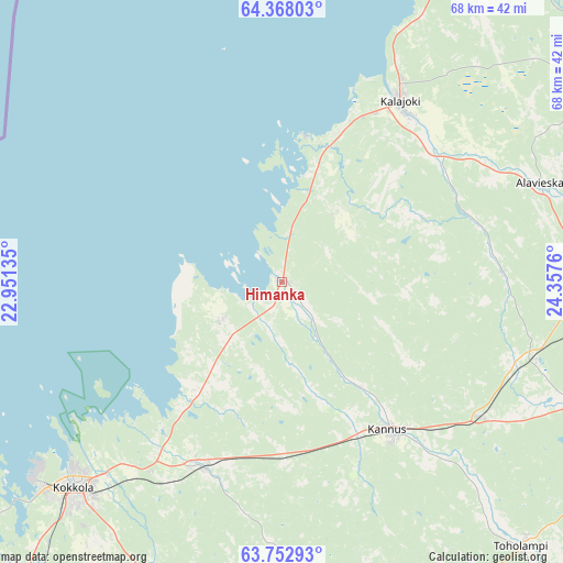
Himanka GPS coordinates[2]
64° 3' 43.848" North, 23° 39' 16.092" East
| Map corner | latitude | longitude |
|---|---|---|
| Upper-left | 64.36803°, | 22.95135° |
| Center: | 64.06218°, | 23.65447° |
| Lower-right: | 63.75293°, | 24.3576° |
| Map W x H: | 68.4×68.4 km | = 42.5×42.5mi |
| max Lat: | 69.90864° ⇑15% North |
| Himanka: | 64.06218° |
| min Lat: | ⇓85% South 59.83333° |
| min Long | Himanka | max Long |
| 21.2° | 23.65447° | 30.93276° |
| W 33.3%⇐ | ⇒66.7% E |
Elevation
Elevation of Himanka is 14 m = 46 ft, and this is 63.1 m = 207 ft below average elevation for this country.
| Max E: |
299 m = 981 ft | 87.6% |
| Avg. | 77.1 m = 253 ft | |
| Himanka | 14 m = 46 ft | |
Min E: |
1 m = 3 ft | 12.4% |
See also: Finland elevation on elevation.city.
Geographical zone
Himanka is located in North temperate zone (between Tropic of Cancer and the Arctic Circle). Distance of this North polar circle is 278.1 km =172.8 mi to North.| Distance of | km | miles | from Himanka |
|---|---|---|---|
| North Pole | 2884 | 1792 | to North |
| Arctic Circle | 278.1 | 172.8 | to North |
| Tropic Cancer | 4517.1 | 2806.8 | to South |
| Equator | 7123 | 4426 | to South |


Nearby cities:
15 places around Himanka: (largest is in red/bold)
• Alavieska
33.4 km =20.8 mi,  69°
69°
• Kalajoki
25.3 km =15.7 mi,  34°
34°
• Kannus
21.6 km =13.4 mi,  146°
146°
• Kaustinen
57.1 km =35.5 mi,  178°
178°
• Kokkola
35.7 km =22.2 mi,  225°
225°
• Kronoby
47.9 km =29.8 mi,  219°
219°
• Kälviä
24.5 km =15.2 mi,  203°
203°
• Larsmo
56.1 km =34.9 mi, 232°
• Lohtaja
8.4 km =5.2 mi,  240°
240°
• Merijärvi
46.7 km =29 mi,  55°
55°
• Pyhäjoki
53 km =32.9 mi, 31°
• Sievi
45 km =28 mi,  113°
113°
• Toholampi
43.9 km =27.3 mi,  138°
138°
• Ullava
55.5 km =34.5 mi,  157°
157°
• Ylivieska
43.6 km =27.1 mi,  86°
86°
Sources, notices
• [Note1] Compared only with cities in Finland existing in our database
• [Src1] Map data: © OpenStreetMap contributors (CC-BY-SA)
• [Src2] Other city data from geonames.org with taken over terms of usage.
• [Src3] Geographical zone / Annual Mean Temperature by Robert A. Rohde @ Wikipedia
