Kokkola geodata
Kokkola (Central Ostrobothnia) is a seat of a first-order administrative division; located in Finland in Europe/Helsinki (GMT+3) time zone. With population of 35,586 people, there are 24 cities with bigger population in this country. Compared to other cities in Finland, 83.5% of cities are located further ↓South; 73.7% of cities are located further →East and 93.4% of cities have higher elevation than Kokkola. Note1


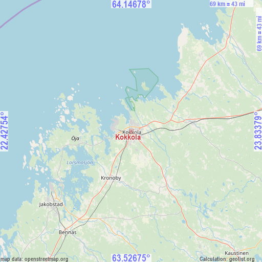
Kokkola GPS coordinates[2]
63° 50' 18.492" North, 23° 7' 50.376" East
| Map corner | latitude | longitude |
|---|---|---|
| Upper-left | 64.14678°, | 22.42754° |
| Center: | 63.83847°, | 23.13066° |
| Lower-right: | 63.52675°, | 23.83379° |
| Map W x H: | 68.9×68.9 km | = 42.8×42.8mi |
| max Lat: | 69.90864° ⇑16.5% North |
| Kokkola: | 63.83847° |
| min Lat: | ⇓83.5% South 59.83333° |
| min Long | Kokkola | max Long |
| 21.2° | 23.13066° | 30.93276° |
| W 26.3%⇐ | ⇒73.7% E |
Elevation
Elevation of Kokkola is 9 m = 30 ft, and this is 68.1 m = 223 ft below average elevation for this country.
| Max E: |
299 m = 981 ft | 93.4% |
| Avg. | 77.1 m = 253 ft | |
| Kokkola | 9 m = 30 ft | |
Min E: |
1 m = 3 ft | 6.6% |
See also: Finland elevation on elevation.city.
Geographical zone
Kokkola is located in North temperate zone (between Tropic of Cancer and the Arctic Circle). Distance of this North polar circle is 303 km =188.3 mi to North.| Distance of | km | miles | from Kokkola |
|---|---|---|---|
| North Pole | 2908.9 | 1807.5 | to North |
| Arctic Circle | 303 | 188.3 | to North |
| Tropic Cancer | 4492.3 | 2791.4 | to South |
| Equator | 7098.2 | 4410.6 | to South |


Nearby cities:
15 places around Kokkola: (largest is in red/bold)
• Bennäs
31.1 km =19.3 mi,  211°
211°
• Evijärvi
55.3 km =34.4 mi,  161°
161°
• Himanka
35.7 km =22.2 mi,  45°
45°
• Jakobstad
27.8 km =17.3 mi,  229°
229°
• Kannus
38.3 km =23.8 mi,  79°
79°
• Kaustinen
42.3 km =26.3 mi,  139°
139°
• Kronoby
13.1 km =8.1 mi,  201°
201°
• Kälviä
16 km =9.9 mi, 81°
• Larsmo
21 km =13 mi,  243°
243°
• Lohtaja
27.6 km =17.1 mi,  41°
41°
• Nykarleby
45.9 km =28.5 mi,  220°
220°
• Pedersöre
30.4 km =18.9 mi, 226°
• Toholampi
55.5 km =34.5 mi,  98°
98°
• Ullava
53.9 km =33.5 mi,  119°
119°
• Veteli
51.4 km =31.9 mi, 141°
Sources, notices
• [Note1] Compared only with cities in Finland existing in our database
• [Src1] Map data: © OpenStreetMap contributors (CC-BY-SA)
• [Src2] Other city data from geonames.org with taken over terms of usage.
• [Src3] Geographical zone / Annual Mean Temperature by Robert A. Rohde @ Wikipedia
