Karkkila geodata
Karkkila (Uusimaa) is a seat of a third-order administrative division; located in Finland in Europe/Helsinki (GMT+3) time zone. With population of 8,811 people, there are 124 cities with bigger population in this country. Compared to other cities in Finland, 83.3% of cities are located further ↑North; 58.5% of cities are located further →East and 54.7% of cities have higher elevation than Karkkila. Note1


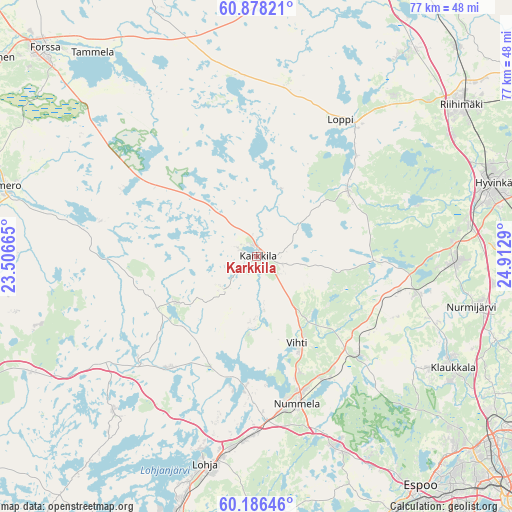
Karkkila GPS coordinates[2]
60° 32' 3.048" North, 24° 12' 35.172" East
| Map corner | latitude | longitude |
|---|---|---|
| Upper-left | 60.87821°, | 23.50665° |
| Center: | 60.53418°, | 24.20977° |
| Lower-right: | 60.18646°, | 24.9129° |
| Map W x H: | 76.9×76.9 km | = 47.8×47.8mi |
| max Lat: | 69.90864° ⇑83.3% North |
| Karkkila: | 60.53418° |
| min Lat: | ⇓16.7% South 59.83333° |
| min Long | Karkkila | max Long |
| 21.2° | 24.20977° | 30.93276° |
| W 41.5%⇐ | ⇒58.5% E |
Elevation
Elevation of Karkkila is 74 m = 243 ft, and this is 3.1 m = 10 ft below average elevation for this country.
| Max E: |
299 m = 981 ft | 54.7% |
| Avg. | 77.1 m = 253 ft | |
| Karkkila | 74 m = 243 ft | |
Min E: |
1 m = 3 ft | 45.3% |
See also: Finland elevation on elevation.city.
Geographical zone
Karkkila is located in North temperate zone (between Tropic of Cancer and the Arctic Circle). Distance of this North polar circle is 670.4 km =416.6 mi to North.| Distance of | km | miles | from Karkkila |
|---|---|---|---|
| North Pole | 3276.3 | 2035.8 | to North |
| Arctic Circle | 670.4 | 416.6 | to North |
| Tropic Cancer | 4124.9 | 2563.1 | to South |
| Equator | 6730.8 | 4182.3 | to South |


Nearby cities:
15 places around Karkkila: (largest is in red/bold)
• Hyvinge
37.5 km =23.3 mi,  72°
72°
• Kiikala
36 km =22.4 mi,  257°
257°
• Kärkölä
17 km =10.6 mi,  300°
300°
• Lohja
32.7 km =20.3 mi,  194°
194°
• Loppi
24.2 km =15 mi,  32°
32°
• Nurmijärvi
33.6 km =20.9 mi,  103°
103°
• Renko
40.4 km =25.1 mi,  6°
6°
• Riihimäki
38.3 km =23.8 mi,  53°
53°
• Sammatti
32 km =19.9 mi,  221°
221°
• Saukkola
20.9 km =13 mi, 216°
• Somero
38.1 km =23.7 mi,  283°
283°
• Suomusjärvi
36.9 km =22.9 mi,  236°
236°
• Tammela
39 km =24.2 mi,  321°
321°
• Tervakoski
38.5 km =23.9 mi,  36°
36°
• Vihti
14.4 km =8.9 mi,  155°
155°
Sources, notices
• [Note1] Compared only with cities in Finland existing in our database
• [Src1] Map data: © OpenStreetMap contributors (CC-BY-SA)
• [Src2] Other city data from geonames.org with taken over terms of usage.
• [Src3] Geographical zone / Annual Mean Temperature by Robert A. Rohde @ Wikipedia
