Weyer geodata
Weyer (Grand Est) is a populated place; located in France in Europe/Paris (GMT+2) time zone. With population of 531 people, there are 14589 cities with bigger population in this country. Compared to other cities in France, 76.7% of cities are located further ↓South; 95.5% of cities are located further ←West and 78.4% of cities have lower elevation than Weyer. Note1
Administrative division(s):
- Level 1: Grand Est
- Level 2: Bas-Rhin
- Level 3: Arrondissement de Saverne
- Level 4: Weyer


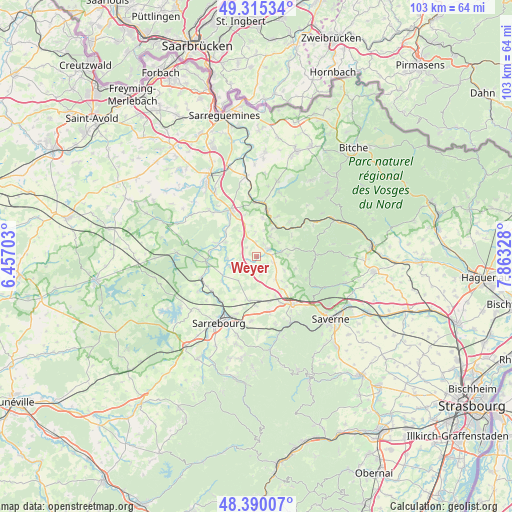
Weyer GPS coordinates[2]
48° 51' 17.424" North, 7° 9' 36.54" East
| Map corner | latitude | longitude |
|---|---|---|
| Upper-left | 49.31534°, | 6.45703° |
| Center: | 48.85484°, | 7.16015° |
| Lower-right: | 48.39007°, | 7.86328° |
| Map W x H: | 102.9×102.9 km | = 63.9×63.9mi |
| max Lat: | 51.07786° ⇑23.3% North |
| Weyer: | 48.85484° |
| min Lat: | ⇓76.7% South 41.3874° |
| min Long | Weyer | max Long |
| -5.08615° | 7.16015° | 9.52242° |
| W 95.5%⇐ | ⇒4.5% E |
Elevation
Elevation of Weyer is 275 m = 902 ft, and this is 81.3 m = 267 ft above average elevation for this country.
| Max E: |
2333 m = 7654 ft | 21.6% |
| Weyer | 275 m 902 ft | |
| Avg. | 193.7 m = 635 ft | |
Min E: |
-1 m = -3 ft | 78.4% |
See also: France elevation on elevation.city.
Geographical zone
Weyer is located in North temperate zone (between Tropic of Cancer and the Arctic Circle). Distance of this North polar circle is 1969 km =1223.5 mi to North.| Distance of | km | miles | from Weyer |
|---|---|---|---|
| North Pole | 4574.9 | 2842.7 | to North |
| Arctic Circle | 1969 | 1223.5 | to North |
| Tropic Cancer | 2826.2 | 1756.1 | to South |
| Equator | 5432.1 | 3375.3 | to South |


Nearby cities:
15 places around Weyer: (largest is in red/bold)
• Diemeringen
9.7 km =6 mi,  12°
12°
• Drulingen
2.6 km =1.6 mi,  55°
55°
• Eschbourg
10.9 km =6.8 mi,  114°
114°
• Fénétrange
10.1 km =6.3 mi,  265°
265°
• Hilbesheim
9.8 km =6.1 mi,  207°
207°
• Lixheim
8.9 km =5.5 mi,  188°
188°
• Lohr
6.2 km =3.9 mi,  86°
86°
• Mackwiller
7.9 km =4.9 mi, 8°
• Mittelbronn
10.6 km =6.6 mi,  152°
152°
• Petersbach
8 km =5 mi,  77°
77°
• Saint-Jean-Kourtzerode
11.2 km =7 mi,  167°
167°
• Sarre-Union
10.5 km =6.5 mi,  332°
332°
• Sarrewerden
9.4 km =5.8 mi,  323°
323°
• Waldhambach
9 km =5.6 mi,  27°
27°
• Weislingen
10 km =6.2 mi,  43°
43°
Sources, notices
• [Note1] Compared only with cities in France existing in our database
• [Src1] Map data: © OpenStreetMap contributors (CC-BY-SA)
• [Src2] Other city data from geonames.org with taken over terms of usage.
• [Src3] Geographical zone / Annual Mean Temperature by Robert A. Rohde @ Wikipedia
