Drulingen geodata
Drulingen (Grand Est) is a populated place; located in France in Europe/Paris (GMT+2) time zone. With population of 1,571 people, there are 5936 cities with bigger population in this country. Compared to other cities in France, 77% of cities are located further ↓South; 95.7% of cities are located further ←West and 80.6% of cities have lower elevation than Drulingen. Note1
Administrative division(s):
- Level 1: Grand Est
- Level 2: Bas-Rhin
- Level 3: Arrondissement de Saverne
- Level 4: Drulingen


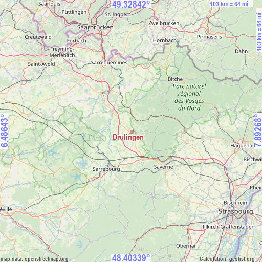
Drulingen GPS coordinates[2]
48° 52' 4.944" North, 7° 11' 22.416" East
| Map corner | latitude | longitude |
|---|---|---|
| Upper-left | 49.32842°, | 6.48643° |
| Center: | 48.86804°, | 7.18956° |
| Lower-right: | 48.40339°, | 7.89268° |
| Map W x H: | 102.9×102.9 km | = 63.9×63.9mi |
| max Lat: | 51.07786° ⇑23% North |
| Drulingen: | 48.86804° |
| min Lat: | ⇓77% South 41.3874° |
| min Long | Drulingen | max Long |
| -5.08615° | 7.18956° | 9.52242° |
| W 95.7%⇐ | ⇒4.3% E |
Elevation
Elevation of Drulingen is 297 m = 974 ft, and this is 103.3 m = 339 ft above average elevation for this country.
| Max E: |
2333 m = 7654 ft | 19.4% |
| Drulingen | 297 m 974 ft | |
| Avg. | 193.7 m = 635 ft | |
Min E: |
-1 m = -3 ft | 80.6% |
See also: France elevation on elevation.city.
Geographical zone
Drulingen is located in North temperate zone (between Tropic of Cancer and the Arctic Circle). Distance of this North polar circle is 1967.6 km =1222.6 mi to North.| Distance of | km | miles | from Drulingen |
|---|---|---|---|
| North Pole | 4573.4 | 2841.8 | to North |
| Arctic Circle | 1967.6 | 1222.6 | to North |
| Tropic Cancer | 2827.7 | 1757.1 | to South |
| Equator | 5433.6 | 3376.3 | to South |


Nearby cities:
15 places around Drulingen: (largest is in red/bold)
• Butten
11.7 km =7.3 mi,  11°
11°
• Diemeringen
8 km =5 mi,  359°
359°
• Eschbourg
9.9 km =6.2 mi,  127°
127°
• La Petite-Pierre
9.7 km =6 mi,  96°
96°
• Lixheim
10.9 km =6.8 mi,  198°
198°
• Lohr
4.2 km =2.6 mi, 104°
• Mackwiller
6.4 km =4 mi,  350°
350°
• Mittelbronn
11.2 km =7 mi,  165°
165°
• Petersbach
5.6 km =3.5 mi,  86°
86°
• Phalsbourg
12.2 km =7.6 mi,  155°
155°
• Sarre-Union
10.5 km =6.5 mi,  318°
318°
• Sarrewerden
9.8 km =6.1 mi,  308°
308°
• Waldhambach
6.8 km =4.2 mi,  16°
16°
• Weislingen
7.5 km =4.7 mi,  38°
38°
• Weyer
2.6 km =1.6 mi,  235°
235°
Sources, notices
• [Note1] Compared only with cities in France existing in our database
• [Src1] Map data: © OpenStreetMap contributors (CC-BY-SA)
• [Src2] Other city data from geonames.org with taken over terms of usage.
• [Src3] Geographical zone / Annual Mean Temperature by Robert A. Rohde @ Wikipedia
