Bosselshausen geodata
Bosselshausen (Grand Est) is a populated place; located in France in Europe/Paris (GMT+2) time zone. With population of 726 people, there are 11454 cities with bigger population in this country. Compared to other cities in France, 75.7% of cities are located further ↓South; 98% of cities are located further ←West and 66.1% of cities have lower elevation than Bosselshausen. Note1
Administrative division(s):
- Level 1: Grand Est
- Level 2: Bas-Rhin
- Level 3: Arrondissement de Saverne
- Level 4: Bosselshausen


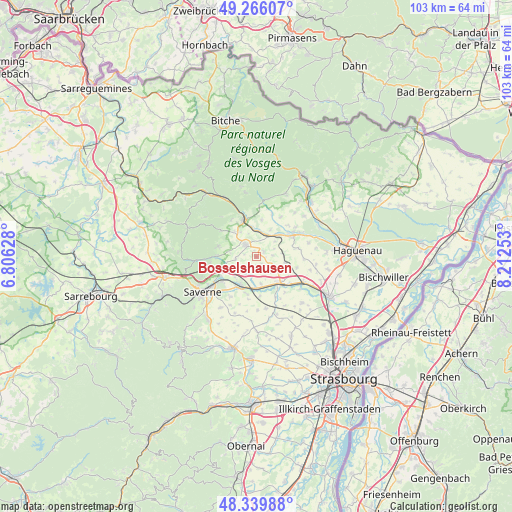
Bosselshausen GPS coordinates[2]
48° 48' 18.396" North, 7° 30' 33.876" East
| Map corner | latitude | longitude |
|---|---|---|
| Upper-left | 49.26607°, | 6.80628° |
| Center: | 48.80511°, | 7.50941° |
| Lower-right: | 48.33988°, | 8.21253° |
| Map W x H: | 103×103 km | = 64×64mi |
| max Lat: | 51.07786° ⇑24.3% North |
| Bosselshausen: | 48.80511° |
| min Lat: | ⇓75.7% South 41.3874° |
| min Long | Bosselshausen | max Long |
| -5.08615° | 7.50941° | 9.52242° |
| W 98%⇐ | ⇒2% E |
Elevation
Elevation of Bosselshausen is 199 m = 653 ft, and this is 5.3 m = 17 ft above average elevation for this country.
| Max E: |
2333 m = 7654 ft | 33.9% |
| Bosselshausen | 199 m 653 ft | |
| Avg. | 193.7 m = 635 ft | |
Min E: |
-1 m = -3 ft | 66.1% |
See also: France elevation on elevation.city.
Geographical zone
Bosselshausen is located in North temperate zone (between Tropic of Cancer and the Arctic Circle). Distance of this North polar circle is 1974.6 km =1227 mi to North.| Distance of | km | miles | from Bosselshausen |
|---|---|---|---|
| North Pole | 4580.4 | 2846.1 | to North |
| Arctic Circle | 1974.6 | 1227 | to North |
| Tropic Cancer | 2820.7 | 1752.7 | to South |
| Equator | 5426.6 | 3371.9 | to South |


Nearby cities:
15 places around Bosselshausen: (largest is in red/bold)
• Alteckendorf
6.6 km =4.1 mi,  103°
103°
• Bouxwiller
3 km =1.9 mi,  316°
316°
• Dettwiller
6.5 km =4 mi,  209°
209°
• Dossenheim-sur-Zinsel
7.8 km =4.8 mi,  270°
270°
• Ettendorf
5.4 km =3.4 mi,  80°
80°
• Hattmatt
6.6 km =4.1 mi,  255°
255°
• Hochfelden
6.8 km =4.2 mi,  141°
141°
• Ingwiller
7.8 km =4.8 mi,  343°
343°
• Lupstein
7.8 km =4.8 mi,  192°
192°
• Melsheim
5.4 km =3.4 mi,  169°
169°
• Menchhoffen
6.1 km =3.8 mi,  350°
350°
• Neuwiller-lès-Saverne
8 km =5 mi,  286°
286°
• Obermodern-Zutzendorf
5.3 km =3.3 mi,  19°
19°
• Steinbourg
8 km =5 mi,  241°
241°
• Wilwisheim
6.3 km =3.9 mi,  181°
181°
Sources, notices
• [Note1] Compared only with cities in France existing in our database
• [Src1] Map data: © OpenStreetMap contributors (CC-BY-SA)
• [Src2] Other city data from geonames.org with taken over terms of usage.
• [Src3] Geographical zone / Annual Mean Temperature by Robert A. Rohde @ Wikipedia
