Vernoil-le-Fourrier geodata
Vernoil-le-Fourrier (Pays de la Loire) is a populated place; located in France in Europe/Paris (GMT+2) time zone. With population of 1,285 people, there are 7101 cities with bigger population in this country. Compared to other cities in France, 50.4% of cities are located further ↑North; 77.4% of cities are located further →East and 69.7% of cities have higher elevation than Vernoil-le-Fourrier. Note1
Administrative division(s):
- Level 1: Pays de la Loire
- Level 2: Département de Maine-et-Loire
- Level 3: Arrondissement de Saumur
- Level 4: Vernoil-le-Fourrier


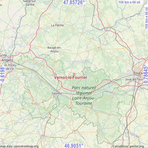
Vernoil-le-Fourrier GPS coordinates[2]
47° 22' 59.988" North, 0° 4' 59.988" East
| Map corner | latitude | longitude |
|---|---|---|
| Upper-left | 47.85726°, | -0.6198° |
| Center: | 47.38333°, | 0.08333° |
| Lower-right: | 46.9051°, | 0.78645° |
| Map W x H: | 105.9×105.9 km | = 65.8×65.8mi |
| max Lat: | 51.07786° ⇑50.4% North |
| Vernoil-le-Fourrier: | 47.38333° |
| min Lat: | ⇓49.6% South 41.3874° |
| min Long | Vernoil-le-Four | max Long |
| -5.08615° | 0.08333° | 9.52242° |
| W 22.6%⇐ | ⇒77.4% E |
Elevation
Elevation of Vernoil-le-Fourrier is 79 m = 259 ft, and this is 114.7 m = 376 ft below average elevation for this country.
| Max E: |
2333 m = 7654 ft | 69.7% |
| Avg. | 193.7 m = 635 ft | |
| Vernoil-le-Fourrier | 79 m = 259 ft | |
Min E: |
-1 m = -3 ft | 30.3% |
See also: France elevation on elevation.city.
Geographical zone
Vernoil-le-Fourrier is located in North temperate zone (between Tropic of Cancer and the Arctic Circle). Distance of this North polar circle is 2132.6 km =1325.1 mi to North.| Distance of | km | miles | from Vernoil-le-Fourrier |
|---|---|---|---|
| North Pole | 4738.5 | 2944.4 | to North |
| Arctic Circle | 2132.6 | 1325.1 | to North |
| Tropic Cancer | 2662.6 | 1654.5 | to South |
| Equator | 5268.5 | 3273.7 | to South |


Nearby cities:
15 places around Vernoil-le-Fourrier: (largest is in red/bold)
• Allonnes
10.9 km =6.8 mi,  203°
203°
• Benais
14 km =8.7 mi,  134°
134°
• Blou
9.5 km =5.9 mi,  255°
255°
• Bourgueil
12.7 km =7.9 mi,  150°
150°
• Brain-sur-Allonnes
9 km =5.6 mi,  188°
188°
• Jumelles
15.2 km =9.4 mi,  292°
292°
• Mouliherne
10.5 km =6.5 mi,  331°
331°
• Neuillé
10.1 km =6.3 mi,  242°
242°
• Noyant
14.4 km =8.9 mi,  10°
10°
• Parçay-les-Pins
8.4 km =5.2 mi,  45°
45°
• Restigné
15.7 km =9.8 mi,  135°
135°
• Saint-Nicolas-de-Bourgueil
11.4 km =7.1 mi,  163°
163°
• Saint-Philbert-du-Peuple
9.6 km =6 mi,  276°
276°
• Vernantes
2.5 km =1.6 mi,  295°
295°
• Vivy
12.2 km =7.6 mi, 238°
Sources, notices
• [Note1] Compared only with cities in France existing in our database
• [Src1] Map data: © OpenStreetMap contributors (CC-BY-SA)
• [Src2] Other city data from geonames.org with taken over terms of usage.
• [Src3] Geographical zone / Annual Mean Temperature by Robert A. Rohde @ Wikipedia
