Vernantes geodata
Vernantes (Pays de la Loire) is a populated place; located in France in Europe/Paris (GMT+2) time zone. With population of 2,002 people, there are 4788 cities with bigger population in this country. Compared to other cities in France, 50.2% of cities are located further ↑North; 77.7% of cities are located further →East and 78.6% of cities have higher elevation than Vernantes. Note1
Administrative division(s):
- Level 1: Pays de la Loire
- Level 2: Département de Maine-et-Loire
- Level 3: Arrondissement de Saumur
- Level 4: Vernantes


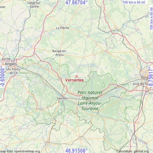
Vernantes GPS coordinates[2]
47° 23' 35.52" North, 0° 3' 10.944" East
| Map corner | latitude | longitude |
|---|---|---|
| Upper-left | 47.86704°, | -0.65008° |
| Center: | 47.3932°, | 0.05304° |
| Lower-right: | 46.91506°, | 0.75617° |
| Map W x H: | 105.9×105.8 km | = 65.8×65.7mi |
| max Lat: | 51.07786° ⇑50.2% North |
| Vernantes: | 47.3932° |
| min Lat: | ⇓49.8% South 41.3874° |
| min Long | Vernantes | max Long |
| -5.08615° | 0.05304° | 9.52242° |
| W 22.3%⇐ | ⇒77.7% E |
Elevation
Elevation of Vernantes is 58 m = 190 ft, and this is 135.7 m = 445 ft below average elevation for this country.
| Max E: |
2333 m = 7654 ft | 78.6% |
| Avg. | 193.7 m = 635 ft | |
| Vernantes | 58 m = 190 ft | |
Min E: |
-1 m = -3 ft | 21.4% |
See also: France elevation on elevation.city.
Geographical zone
Vernantes is located in North temperate zone (between Tropic of Cancer and the Arctic Circle). Distance of this North polar circle is 2131.5 km =1324.5 mi to North.| Distance of | km | miles | from Vernantes |
|---|---|---|---|
| North Pole | 4737.4 | 2943.7 | to North |
| Arctic Circle | 2131.5 | 1324.5 | to North |
| Tropic Cancer | 2663.7 | 1655.1 | to South |
| Equator | 5269.6 | 3274.4 | to South |


Nearby cities:
15 places around Vernantes: (largest is in red/bold)
• Allonnes
11.3 km =7 mi,  190°
190°
• Benais
16.4 km =10.2 mi,  131°
131°
• Blou
7.7 km =4.8 mi,  242°
242°
• Bocé
16.2 km =10.1 mi,  321°
321°
• Bourgueil
14.9 km =9.3 mi,  145°
145°
• Brain-sur-Allonnes
10 km =6.2 mi,  174°
174°
• Jumelles
12.7 km =7.9 mi,  291°
291°
• Mouliherne
8.6 km =5.3 mi,  341°
341°
• Neuillé
8.8 km =5.5 mi,  229°
229°
• Noyant
13.9 km =8.6 mi,  20°
20°
• Parçay-les-Pins
9.6 km =6 mi,  59°
59°
• Saint-Nicolas-de-Bourgueil
13.3 km =8.3 mi,  155°
155°
• Saint-Philbert-du-Peuple
7.3 km =4.5 mi,  269°
269°
• Vernoil-le-Fourrier
2.5 km =1.6 mi,  115°
115°
• Vivy
11 km =6.8 mi, 227°
Sources, notices
• [Note1] Compared only with cities in France existing in our database
• [Src1] Map data: © OpenStreetMap contributors (CC-BY-SA)
• [Src2] Other city data from geonames.org with taken over terms of usage.
• [Src3] Geographical zone / Annual Mean Temperature by Robert A. Rohde @ Wikipedia
