Violès geodata
Violès (Provence-Alpes-Côte d'Azur) is a populated place; located in France in Europe/Paris (GMT+2) time zone. With population of 1,657 people, there are 5644 cities with bigger population in this country. Compared to other cities in France, 85.8% of cities are located further ↑North; 77.2% of cities are located further ←West and 63.2% of cities have higher elevation than Violès. Note1
Administrative division(s):
- Level 1: Provence-Alpes-Côte d'Azur
- Level 2: Département du Vaucluse
- Level 3: Arrondissement de Carpentras
- Level 4: Violès


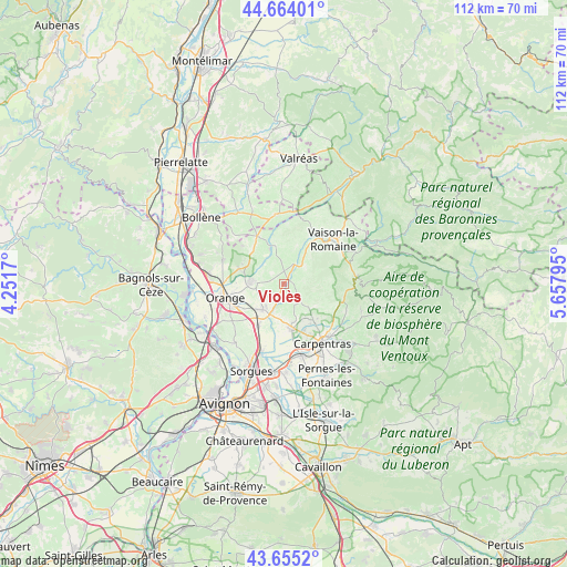
Violès GPS coordinates[2]
44° 9' 42.336" North, 4° 57' 17.388" East
| Map corner | latitude | longitude |
|---|---|---|
| Upper-left | 44.66401°, | 4.2517° |
| Center: | 44.16176°, | 4.95483° |
| Lower-right: | 43.6552°, | 5.65795° |
| Map W x H: | 112.2×112.2 km | = 69.7×69.7mi |
| max Lat: | 51.07786° ⇑85.8% North |
| Violès: | 44.16176° |
| min Lat: | ⇓14.2% South 41.3874° |
| min Long | Violès | max Long |
| -5.08615° | 4.95483° | 9.52242° |
| W 77.2%⇐ | ⇒22.8% E |
Elevation
Elevation of Violès is 94 m = 308 ft, and this is 99.7 m = 327 ft below average elevation for this country.
| Max E: |
2333 m = 7654 ft | 63.2% |
| Avg. | 193.7 m = 635 ft | |
| Violès | 94 m = 308 ft | |
Min E: |
-1 m = -3 ft | 36.8% |
See also: France elevation on elevation.city.
Geographical zone
Violès is located in North temperate zone (between Tropic of Cancer and the Arctic Circle). Distance of this Northern Tropic circle is 2304.4 km =1431.9 mi to South.| Distance of | km | miles | from Violès |
|---|---|---|---|
| North Pole | 5096.7 | 3166.9 | to North |
| Arctic Circle | 2490.8 | 1547.7 | to North |
| Tropic Cancer | 2304.4 | 1431.9 | to South |
| Equator | 4910.3 | 3051.1 | to South |


Nearby cities:
15 places around Violès: (largest is in red/bold)
• Aubignan
8.9 km =5.5 mi,  140°
140°
• Beaumes-de-Venise
7.5 km =4.7 mi,  125°
125°
• Cairanne
8.1 km =5 mi,  347°
347°
• Camaret-sur-Aigues
6.5 km =4 mi,  271°
271°
• Courthézon
10 km =6.2 mi,  214°
214°
• Gigondas
4 km =2.5 mi,  86°
86°
• Jonquières
6.7 km =4.2 mi,  220°
220°
• Loriol-du-Comtat
10.2 km =6.3 mi,  158°
158°
• Rasteau
8.1 km =5 mi,  18°
18°
• Sablet
5.3 km =3.3 mi,  49°
49°
• Sarrians
8.8 km =5.5 mi,  171°
171°
• Séguret
7.3 km =4.5 mi, 47°
• Sérignan-du-Comtat
9.4 km =5.8 mi,  288°
288°
• Travaillan
4.9 km =3 mi,  298°
298°
• Vacqueyras
3.5 km =2.2 mi, 138°
Sources, notices
• [Note1] Compared only with cities in France existing in our database
• [Src1] Map data: © OpenStreetMap contributors (CC-BY-SA)
• [Src2] Other city data from geonames.org with taken over terms of usage.
• [Src3] Geographical zone / Annual Mean Temperature by Robert A. Rohde @ Wikipedia
