Beaumes-de-Venise geodata
Beaumes-de-Venise (Provence-Alpes-Côte d'Azur) is a populated place; located in France in Europe/Paris (GMT+2) time zone. With population of 2,182 people, there are 4401 cities with bigger population in this country. Compared to other cities in France, 86.1% of cities are located further ↑North; 78% of cities are located further ←West and 60.8% of cities have higher elevation than Beaumes-de-Venise. Note1
Administrative division(s):
- Level 1: Provence-Alpes-Côte d'Azur
- Level 2: Département du Vaucluse
- Level 3: Arrondissement de Carpentras
- Level 4: Beaumes-de-Venise


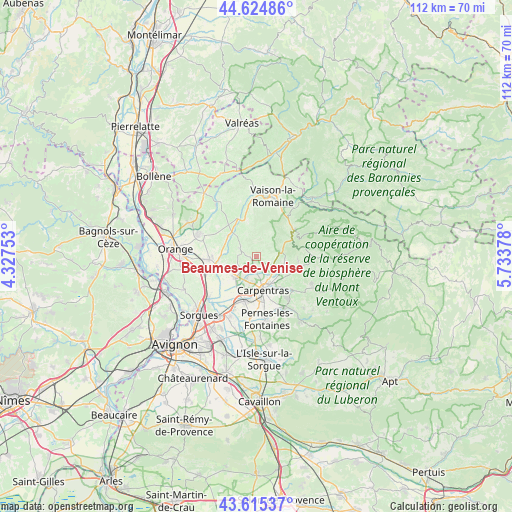
Beaumes-de-Venise GPS coordinates[2]
44° 7' 20.172" North, 5° 1' 50.34" East
| Map corner | latitude | longitude |
|---|---|---|
| Upper-left | 44.62486°, | 4.32753° |
| Center: | 44.12227°, | 5.03065° |
| Lower-right: | 43.61537°, | 5.73378° |
| Map W x H: | 112.2×112.2 km | = 69.7×69.7mi |
| max Lat: | 51.07786° ⇑86.1% North |
| Beaumes-de-Venise: | 44.12227° |
| min Lat: | ⇓13.9% South 41.3874° |
| min Long | Beaumes-de-Veni | max Long |
| -5.08615° | 5.03065° | 9.52242° |
| W 78%⇐ | ⇒22% E |
Elevation
Elevation of Beaumes-de-Venise is 100 m = 328 ft, and this is 93.7 m = 307 ft below average elevation for this country.
| Max E: |
2333 m = 7654 ft | 60.8% |
| Avg. | 193.7 m = 635 ft | |
| Beaumes-de-Venise | 100 m = 328 ft | |
Min E: |
-1 m = -3 ft | 39.2% |
See also: France elevation on elevation.city.
Geographical zone
Beaumes-de-Venise is located in North temperate zone (between Tropic of Cancer and the Arctic Circle). Distance of this Northern Tropic circle is 2300 km =1429.2 mi to South.| Distance of | km | miles | from Beaumes-de-Venise |
|---|---|---|---|
| North Pole | 5101.1 | 3169.7 | to North |
| Arctic Circle | 2495.2 | 1550.4 | to North |
| Tropic Cancer | 2300 | 1429.2 | to South |
| Equator | 4905.9 | 3048.4 | to South |


Nearby cities:
15 places around Beaumes-de-Venise: (largest is in red/bold)
• Aubignan
2.5 km =1.6 mi,  189°
189°
• Caromb
6.3 km =3.9 mi,  101°
101°
• Carpentras
7.6 km =4.7 mi,  169°
169°
• Gigondas
5.1 km =3.2 mi,  336°
336°
• Jonquières
10.5 km =6.5 mi,  266°
266°
• Le Barroux
5.7 km =3.5 mi,  74°
74°
• Loriol-du-Comtat
5.6 km =3.5 mi,  205°
205°
• Malaucène
9.9 km =6.2 mi,  54°
54°
• Mazan
10.6 km =6.6 mi,  133°
133°
• Monteux
10 km =6.2 mi,  195°
195°
• Sablet
8.1 km =5 mi,  345°
345°
• Sarrians
6.4 km =4 mi,  227°
227°
• Séguret
9.3 km =5.8 mi,  356°
356°
• Vacqueyras
4.2 km =2.6 mi,  295°
295°
• Violès
7.5 km =4.7 mi,  305°
305°
Sources, notices
• [Note1] Compared only with cities in France existing in our database
• [Src1] Map data: © OpenStreetMap contributors (CC-BY-SA)
• [Src2] Other city data from geonames.org with taken over terms of usage.
• [Src3] Geographical zone / Annual Mean Temperature by Robert A. Rohde @ Wikipedia
