Aubignan geodata
Aubignan (Provence-Alpes-Côte d'Azur) is a populated place; located in France in Europe/Paris (GMT+2) time zone. With population of 4,336 people, there are 2275 cities with bigger population in this country. Compared to other cities in France, 86.2% of cities are located further ↑North; 77.9% of cities are located further ←West and 73.1% of cities have higher elevation than Aubignan. Note1
Administrative division(s):
- Level 1: Provence-Alpes-Côte d'Azur
- Level 2: Département du Vaucluse
- Level 3: Arrondissement de Carpentras
- Level 4: Aubignan


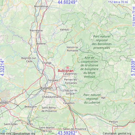
Aubignan GPS coordinates[2]
44° 5' 58.956" North, 5° 1' 30.936" East
| Map corner | latitude | longitude |
|---|---|---|
| Upper-left | 44.60249°, | 4.32214° |
| Center: | 44.09971°, | 5.02526° |
| Lower-right: | 43.59262°, | 5.72839° |
| Map W x H: | 112.3×112.3 km | = 69.8×69.8mi |
| max Lat: | 51.07786° ⇑86.2% North |
| Aubignan: | 44.09971° |
| min Lat: | ⇓13.8% South 41.3874° |
| min Long | Aubignan | max Long |
| -5.08615° | 5.02526° | 9.52242° |
| W 77.9%⇐ | ⇒22.1% E |
Elevation
Elevation of Aubignan is 71 m = 233 ft, and this is 122.7 m = 403 ft below average elevation for this country.
| Max E: |
2333 m = 7654 ft | 73.1% |
| Avg. | 193.7 m = 635 ft | |
| Aubignan | 71 m = 233 ft | |
Min E: |
-1 m = -3 ft | 26.9% |
See also: France elevation on elevation.city.
Geographical zone
Aubignan is located in North temperate zone (between Tropic of Cancer and the Arctic Circle). Distance of this Northern Tropic circle is 2297.5 km =1427.6 mi to South.| Distance of | km | miles | from Aubignan |
|---|---|---|---|
| North Pole | 5103.6 | 3171.2 | to North |
| Arctic Circle | 2497.7 | 1552 | to North |
| Tropic Cancer | 2297.5 | 1427.6 | to South |
| Equator | 4903.4 | 3046.8 | to South |


Nearby cities:
15 places around Aubignan: (largest is in red/bold)
• Beaumes-de-Venise
2.5 km =1.6 mi,  9°
9°
• Caromb
6.7 km =4.2 mi,  79°
79°
• Carpentras
5.3 km =3.3 mi,  159°
159°
• Courthézon
11.4 km =7.1 mi,  263°
263°
• Gigondas
7.3 km =4.5 mi,  347°
347°
• Jonquières
10.2 km =6.3 mi,  280°
280°
• Le Barroux
7.2 km =4.5 mi,  55°
55°
• Loriol-du-Comtat
3.2 km =2 mi,  217°
217°
• Mazan
9.4 km =5.8 mi,  120°
120°
• Monteux
7.4 km =4.6 mi,  198°
198°
• Pernes-les-Fontaines
11.6 km =7.2 mi,  166°
166°
• Sablet
10.5 km =6.5 mi, 351°
• Sarrians
4.7 km =2.9 mi,  246°
246°
• Vacqueyras
5.4 km =3.4 mi,  322°
322°
• Violès
8.9 km =5.5 mi, 320°
Sources, notices
• [Note1] Compared only with cities in France existing in our database
• [Src1] Map data: © OpenStreetMap contributors (CC-BY-SA)
• [Src2] Other city data from geonames.org with taken over terms of usage.
• [Src3] Geographical zone / Annual Mean Temperature by Robert A. Rohde @ Wikipedia
