Sablet geodata
Sablet (Provence-Alpes-Côte d'Azur) is a populated place; located in France in Europe/Paris (GMT+2) time zone. With population of 1,375 people, there are 6704 cities with bigger population in this country. Compared to other cities in France, 85.6% of cities are located further ↑North; 77.7% of cities are located further ←West and 56.8% of cities have lower elevation than Sablet. Note1
Administrative division(s):
- Level 1: Provence-Alpes-Côte d'Azur
- Level 2: Département du Vaucluse
- Level 3: Arrondissement de Carpentras
- Level 4: Sablet


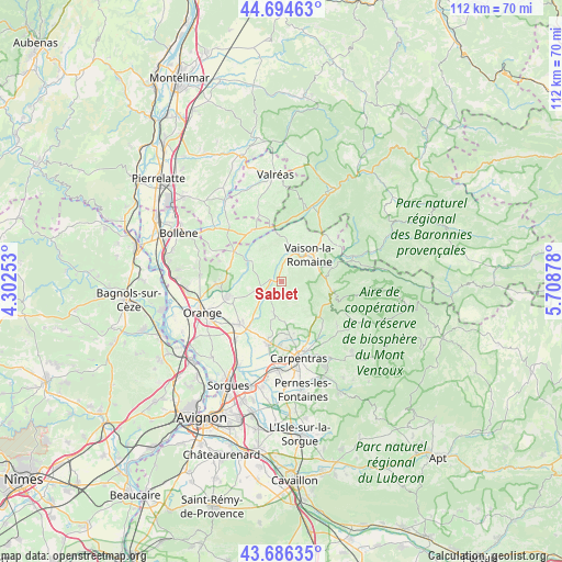
Sablet GPS coordinates[2]
44° 11' 33.54" North, 5° 0' 20.376" East
| Map corner | latitude | longitude |
|---|---|---|
| Upper-left | 44.69463°, | 4.30253° |
| Center: | 44.19265°, | 5.00566° |
| Lower-right: | 43.68635°, | 5.70878° |
| Map W x H: | 112.1×112.1 km | = 69.7×69.7mi |
| max Lat: | 51.07786° ⇑85.6% North |
| Sablet: | 44.19265° |
| min Lat: | ⇓14.4% South 41.3874° |
| min Long | Sablet | max Long |
| -5.08615° | 5.00566° | 9.52242° |
| W 77.7%⇐ | ⇒22.3% E |
Elevation
Elevation of Sablet is 157 m = 515 ft, and this is 36.7 m = 120 ft below average elevation for this country.
| Max E: |
2333 m = 7654 ft | 43.2% |
| Avg. | 193.7 m = 635 ft | |
| Sablet | 157 m = 515 ft | |
Min E: |
-1 m = -3 ft | 56.8% |
See also: France elevation on elevation.city.
Geographical zone
Sablet is located in North temperate zone (between Tropic of Cancer and the Arctic Circle). Distance of this Northern Tropic circle is 2307.8 km =1434 mi to South.| Distance of | km | miles | from Sablet |
|---|---|---|---|
| North Pole | 5093.3 | 3164.8 | to North |
| Arctic Circle | 2487.4 | 1545.6 | to North |
| Tropic Cancer | 2307.8 | 1434 | to South |
| Equator | 4913.8 | 3053.3 | to South |


Nearby cities:
15 places around Sablet: (largest is in red/bold)
• Aubignan
10.5 km =6.5 mi,  171°
171°
• Beaumes-de-Venise
8.1 km =5 mi, 165°
• Cairanne
7.3 km =4.5 mi,  307°
307°
• Entrechaux
10.9 km =6.8 mi,  75°
75°
• Gigondas
3.2 km =2 mi,  180°
180°
• Le Barroux
9.8 km =6.1 mi,  129°
129°
• Malaucène
10.3 km =6.4 mi,  101°
101°
• Rasteau
4.5 km =2.8 mi,  340°
340°
• Roaix
5.9 km =3.7 mi,  8°
8°
• Séguret
2 km =1.2 mi,  42°
42°
• Travaillan
8.4 km =5.2 mi,  262°
262°
• Vacqueyras
6.3 km =3.9 mi,  196°
196°
• Vaison-la-Romaine
7.5 km =4.7 mi,  46°
46°
• Villedieu
10.5 km =6.5 mi, 12°
• Violès
5.3 km =3.3 mi,  229°
229°
Sources, notices
• [Note1] Compared only with cities in France existing in our database
• [Src1] Map data: © OpenStreetMap contributors (CC-BY-SA)
• [Src2] Other city data from geonames.org with taken over terms of usage.
• [Src3] Geographical zone / Annual Mean Temperature by Robert A. Rohde @ Wikipedia
