Cairanne geodata
Cairanne (Provence-Alpes-Côte d'Azur) is a populated place; located in France in Europe/Paris (GMT+2) time zone. With population of 912 people, there are 9558 cities with bigger population in this country. Compared to other cities in France, 85.3% of cities are located further ↑North; 76.9% of cities are located further ←West and 61.9% of cities have lower elevation than Cairanne. Note1
Administrative division(s):
- Level 1: Provence-Alpes-Côte d'Azur
- Level 2: Département du Vaucluse
- Level 3: Arrondissement de Carpentras
- Level 4: Cairanne


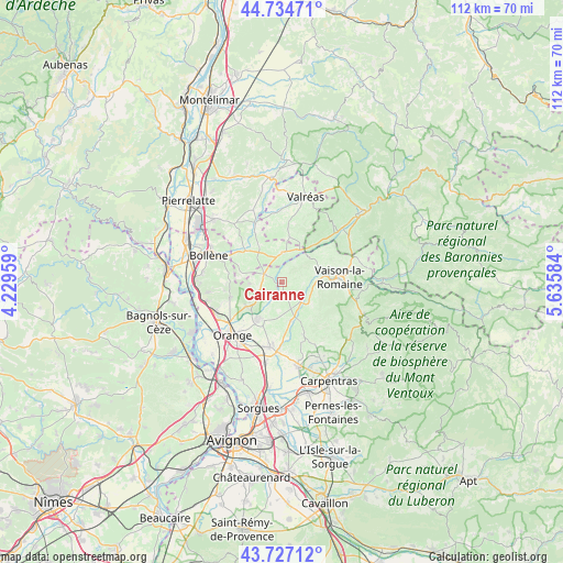
Cairanne GPS coordinates[2]
44° 13' 59.052" North, 4° 55' 57.792" East
| Map corner | latitude | longitude |
|---|---|---|
| Upper-left | 44.73471°, | 4.22959° |
| Center: | 44.23307°, | 4.93272° |
| Lower-right: | 43.72712°, | 5.63584° |
| Map W x H: | 112×112 km | = 69.6×69.6mi |
| max Lat: | 51.07786° ⇑85.3% North |
| Cairanne: | 44.23307° |
| min Lat: | ⇓14.7% South 41.3874° |
| min Long | Cairanne | max Long |
| -5.08615° | 4.93272° | 9.52242° |
| W 76.9%⇐ | ⇒23.1% E |
Elevation
Elevation of Cairanne is 179 m = 587 ft, and this is 14.7 m = 48 ft below average elevation for this country.
| Max E: |
2333 m = 7654 ft | 38.1% |
| Avg. | 193.7 m = 635 ft | |
| Cairanne | 179 m = 587 ft | |
Min E: |
-1 m = -3 ft | 61.9% |
See also: France elevation on elevation.city.
Geographical zone
Cairanne is located in North temperate zone (between Tropic of Cancer and the Arctic Circle). Distance of this Northern Tropic circle is 2312.3 km =1436.8 mi to South.| Distance of | km | miles | from Cairanne |
|---|---|---|---|
| North Pole | 5088.8 | 3162 | to North |
| Arctic Circle | 2482.9 | 1542.8 | to North |
| Tropic Cancer | 2312.3 | 1436.8 | to South |
| Equator | 4918.3 | 3056.1 | to South |


Nearby cities:
15 places around Cairanne: (largest is in red/bold)
• Bouchet
8.7 km =5.4 mi,  327°
327°
• Camaret-sur-Aigues
9.1 km =5.7 mi,  211°
211°
• Gigondas
9.6 km =6 mi,  143°
143°
• Rasteau
4.3 km =2.7 mi,  93°
93°
• Roaix
6.8 km =4.2 mi,  78°
78°
• Rochegude
8.5 km =5.3 mi,  278°
278°
• Sablet
7.3 km =4.5 mi,  127°
127°
• Sainte-Cécile-les-Vignes
4 km =2.5 mi,  290°
290°
• Suze-la-Rousse
9.5 km =5.9 mi,  309°
309°
• Séguret
7.8 km =4.8 mi,  112°
112°
• Sérignan-du-Comtat
8.6 km =5.3 mi,  235°
235°
• Travaillan
6.1 km =3.8 mi,  204°
204°
• Tulette
5.9 km =3.7 mi,  358°
358°
• Violès
8.1 km =5 mi,  167°
167°
• Visan
9.2 km =5.7 mi,  8°
8°
Sources, notices
• [Note1] Compared only with cities in France existing in our database
• [Src1] Map data: © OpenStreetMap contributors (CC-BY-SA)
• [Src2] Other city data from geonames.org with taken over terms of usage.
• [Src3] Geographical zone / Annual Mean Temperature by Robert A. Rohde @ Wikipedia
