Bougé-Chambalud geodata
Bougé-Chambalud (Auvergne-Rhône-Alpes) is a populated place; located in France in Europe/Paris (GMT+2) time zone. With population of 992 people, there are 8887 cities with bigger population in this country. Compared to other cities in France, 76% of cities are located further ↑North; 76.5% of cities are located further ←West and 68.1% of cities have lower elevation than Bougé-Chambalud. Note1
Administrative division(s):
- Level 1: Auvergne-Rhône-Alpes
- Level 2: Département de l'Isère
- Level 3: Arrondissement de Vienne
- Level 4: Bougé-Chambalud


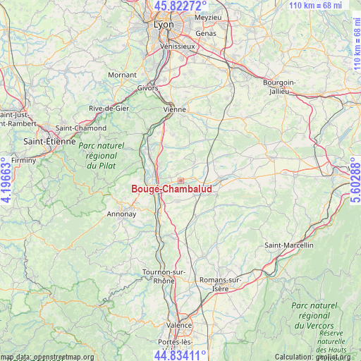
Bougé-Chambalud GPS coordinates[2]
45° 19' 50.052" North, 4° 53' 59.136" East
| Map corner | latitude | longitude |
|---|---|---|
| Upper-left | 45.82272°, | 4.19663° |
| Center: | 45.33057°, | 4.89976° |
| Lower-right: | 44.83411°, | 5.60288° |
| Map W x H: | 109.9×109.9 km | = 68.3×68.3mi |
| max Lat: | 51.07786° ⇑76% North |
| Bougé-Chambalud: | 45.33057° |
| min Lat: | ⇓24% South 41.3874° |
| min Long | Bougé-Chambalu | max Long |
| -5.08615° | 4.89976° | 9.52242° |
| W 76.5%⇐ | ⇒23.5% E |
Elevation
Elevation of Bougé-Chambalud is 210 m = 689 ft, and this is 16.3 m = 53 ft above average elevation for this country.
| Max E: |
2333 m = 7654 ft | 31.9% |
| Bougé-Chambalud | 210 m 689 ft | |
| Avg. | 193.7 m = 635 ft | |
Min E: |
-1 m = -3 ft | 68.1% |
See also: France elevation on elevation.city.
Geographical zone
Bougé-Chambalud is located in North temperate zone (between Tropic of Cancer and the Arctic Circle). Distance of this North polar circle is 2360.9 km =1467 mi to North.| Distance of | km | miles | from Bougé-Chambalud |
|---|---|---|---|
| North Pole | 4966.8 | 3086.2 | to North |
| Arctic Circle | 2360.9 | 1467 | to North |
| Tropic Cancer | 2434.4 | 1512.7 | to South |
| Equator | 5040.3 | 3131.9 | to South |


Nearby cities:
15 places around Bougé-Chambalud: (largest is in red/bold)
• Agnin
3.8 km =2.4 mi,  286°
286°
• Anjou
2.3 km =1.4 mi,  329°
329°
• Anneyron
6.6 km =4.1 mi,  189°
189°
• Bellegarde-Poussieu
6.5 km =4 mi,  39°
39°
• Chanas
6.5 km =4 mi,  258°
258°
• Jarcieu
3.5 km =2.2 mi,  83°
83°
• La Chapelle-de-Surieu
6.9 km =4.3 mi,  5°
5°
• Lapeyrouse-Mornay
7.5 km =4.7 mi,  95°
95°
• Pact
7.4 km =4.6 mi,  71°
71°
• Roussillon
8.2 km =5.1 mi,  306°
306°
• Saint-Sorlin-en-Valloire
6.1 km =3.8 mi,  141°
141°
• Salaise-sur-Sanne
7.3 km =4.5 mi, 288°
• Sonnay
3.1 km =1.9 mi, 7°
• Ville-sous-Anjou
6.1 km =3.8 mi,  320°
320°
• Épinouze
3.3 km =2.1 mi,  134°
134°
Sources, notices
• [Note1] Compared only with cities in France existing in our database
• [Src1] Map data: © OpenStreetMap contributors (CC-BY-SA)
• [Src2] Other city data from geonames.org with taken over terms of usage.
• [Src3] Geographical zone / Annual Mean Temperature by Robert A. Rohde @ Wikipedia
