Villers-Bretonneux geodata
Villers-Bretonneux (Hauts-de-France) is a populated place; located in France in Europe/Paris (GMT+2) time zone. With population of 3,996 people, there are 2461 cities with bigger population in this country. Compared to other cities in France, 92.7% of cities are located further ↓South; 50.9% of cities are located further ←West and 60% of cities have higher elevation than Villers-Bretonneux. Note1
Administrative division(s):
- Level 1: Hauts-de-France
- Level 2: Somme
- Level 3: Amiens
- Level 4: Villers-Bretonneux


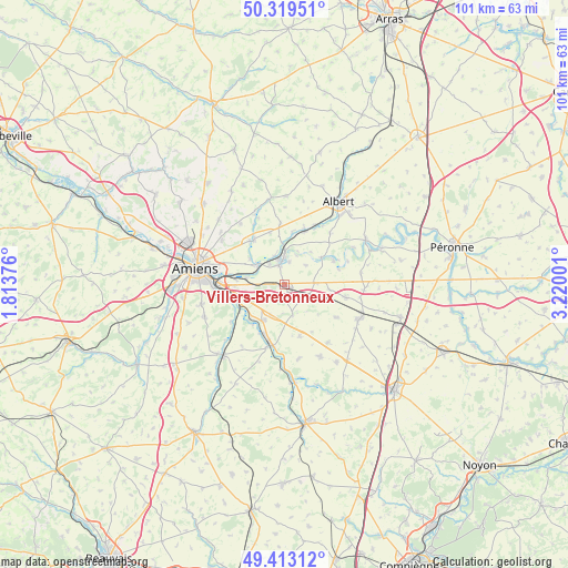
Villers-Bretonneux GPS coordinates[2]
49° 52' 6.384" North, 2° 31' 0.768" East
| Map corner | latitude | longitude |
|---|---|---|
| Upper-left | 50.31951°, | 1.81376° |
| Center: | 49.86844°, | 2.51688° |
| Lower-right: | 49.41312°, | 3.22001° |
| Map W x H: | 100.8×100.8 km | = 62.6×62.6mi |
| max Lat: | 51.07786° ⇑7.3% North |
| Villers-Bretonneux: | 49.86844° |
| min Lat: | ⇓92.7% South 41.3874° |
| min Long | Villers-Bretonn | max Long |
| -5.08615° | 2.51688° | 9.52242° |
| W 50.9%⇐ | ⇒49.1% E |
Elevation
Elevation of Villers-Bretonneux is 102 m = 335 ft, and this is 91.7 m = 301 ft below average elevation for this country.
| Max E: |
2333 m = 7654 ft | 60% |
| Avg. | 193.7 m = 635 ft | |
| Villers-Bretonneux | 102 m = 335 ft | |
Min E: |
-1 m = -3 ft | 40% |
See also: France elevation on elevation.city.
Geographical zone
Villers-Bretonneux is located in North temperate zone (between Tropic of Cancer and the Arctic Circle). Distance of this North polar circle is 1856.3 km =1153.5 mi to North.| Distance of | km | miles | from Villers-Bretonneux |
|---|---|---|---|
| North Pole | 4462.2 | 2772.7 | to North |
| Arctic Circle | 1856.3 | 1153.5 | to North |
| Tropic Cancer | 2938.9 | 1826.1 | to South |
| Equator | 5544.9 | 3445.4 | to South |


Nearby cities:
15 places around Villers-Bretonneux: (largest is in red/bold)
• Aubigny
4.5 km =2.8 mi,  325°
325°
• Blangy-Tronville
6.9 km =4.3 mi,  279°
279°
• Boves
9 km =5.6 mi,  254°
254°
• Caix
10.9 km =6.8 mi,  121°
121°
• Corbie
4.3 km =2.7 mi,  350°
350°
• Daours
6.5 km =4 mi,  307°
307°
• Glisy
8.6 km =5.3 mi, 276°
• Harbonnières
11 km =6.8 mi,  100°
100°
• Marcelcave
4.6 km =2.9 mi, 115°
• Moreuil
10.7 km =6.6 mi,  193°
193°
• Mézières-en-Santerre
9.4 km =5.8 mi,  163°
163°
• Pont-Noyelles
9.6 km =6 mi, 327°
• Querrieu
10 km =6.2 mi,  321°
321°
• Ribemont-sur-Ancre
9.7 km =6 mi,  21°
21°
• Vecquemont
5.9 km =3.7 mi, 306°
Sources, notices
• [Note1] Compared only with cities in France existing in our database
• [Src1] Map data: © OpenStreetMap contributors (CC-BY-SA)
• [Src2] Other city data from geonames.org with taken over terms of usage.
• [Src3] Geographical zone / Annual Mean Temperature by Robert A. Rohde @ Wikipedia
