Aubigny geodata
Aubigny (Hauts-de-France) is a populated place; located in France in Europe/Paris (GMT+2) time zone. With population of 544 people, there are 14318 cities with bigger population in this country. Compared to other cities in France, 93% of cities are located further ↓South; 50.3% of cities are located further ←West and 86.2% of cities have higher elevation than Aubigny. Note1
Administrative division(s):
- Level 1: Hauts-de-France
- Level 2: Somme
- Level 3: Amiens
- Level 4: Aubigny


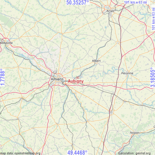
Aubigny GPS coordinates[2]
49° 54' 6.516" North, 2° 28' 54.912" East
| Map corner | latitude | longitude |
|---|---|---|
| Upper-left | 50.35257°, | 1.7788° |
| Center: | 49.90181°, | 2.48192° |
| Lower-right: | 49.4468°, | 3.18505° |
| Map W x H: | 100.7×100.7 km | = 62.6×62.6mi |
| max Lat: | 51.07786° ⇑7% North |
| Aubigny: | 49.90181° |
| min Lat: | ⇓93% South 41.3874° |
| min Long | Aubigny | max Long |
| -5.08615° | 2.48192° | 9.52242° |
| W 50.3%⇐ | ⇒49.7% E |
Elevation
Elevation of Aubigny is 39 m = 128 ft, and this is 154.7 m = 508 ft below average elevation for this country.
| Max E: |
2333 m = 7654 ft | 86.2% |
| Avg. | 193.7 m = 635 ft | |
| Aubigny | 39 m = 128 ft | |
Min E: |
-1 m = -3 ft | 13.8% |
See also: France elevation on elevation.city.
Geographical zone
Aubigny is located in North temperate zone (between Tropic of Cancer and the Arctic Circle). Distance of this North polar circle is 1852.6 km =1151.2 mi to North.| Distance of | km | miles | from Aubigny |
|---|---|---|---|
| North Pole | 4458.5 | 2770.4 | to North |
| Arctic Circle | 1852.6 | 1151.2 | to North |
| Tropic Cancer | 2942.6 | 1828.4 | to South |
| Equator | 5548.6 | 3447.7 | to South |


Nearby cities:
15 places around Aubigny: (largest is in red/bold)
• Allonville
9.5 km =5.9 mi,  296°
296°
• Blangy-Tronville
4.9 km =3 mi,  239°
239°
• Boves
8.7 km =5.4 mi,  224°
224°
• Cagny
10.9 km =6.8 mi,  246°
246°
• Camon
9.9 km =6.2 mi,  260°
260°
• Corbie
1.9 km =1.2 mi,  72°
72°
• Daours
2.7 km =1.7 mi,  274°
274°
• Glisy
6.6 km =4.1 mi, 245°
• Longueau
9.4 km =5.8 mi, 249°
• Marcelcave
8.7 km =5.4 mi,  130°
130°
• Pont-Noyelles
5.1 km =3.2 mi,  328°
328°
• Querrieu
5.5 km =3.4 mi,  318°
318°
• Ribemont-sur-Ancre
8.1 km =5 mi,  48°
48°
• Vecquemont
2.2 km =1.4 mi, 265°
• Villers-Bretonneux
4.5 km =2.8 mi,  145°
145°
Sources, notices
• [Note1] Compared only with cities in France existing in our database
• [Src1] Map data: © OpenStreetMap contributors (CC-BY-SA)
• [Src2] Other city data from geonames.org with taken over terms of usage.
• [Src3] Geographical zone / Annual Mean Temperature by Robert A. Rohde @ Wikipedia
