Marcelcave geodata
Marcelcave (Hauts-de-France) is a populated place; located in France in Europe/Paris (GMT+2) time zone. With population of 1,000 people, there are 8833 cities with bigger population in this country. Compared to other cities in France, 92.6% of cities are located further ↓South; 51.8% of cities are located further ←West and 61.5% of cities have higher elevation than Marcelcave. Note1
Administrative division(s):
- Level 1: Hauts-de-France
- Level 2: Somme
- Level 3: Amiens
- Level 4: Marcelcave


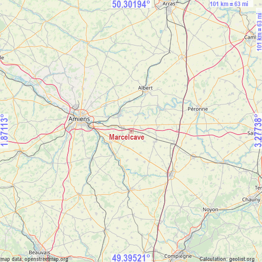
Marcelcave GPS coordinates[2]
49° 51' 2.52" North, 2° 34' 27.3" East
| Map corner | latitude | longitude |
|---|---|---|
| Upper-left | 50.30194°, | 1.87113° |
| Center: | 49.8507°, | 2.57425° |
| Lower-right: | 49.39521°, | 3.27738° |
| Map W x H: | 100.8×100.8 km | = 62.6×62.6mi |
| max Lat: | 51.07786° ⇑7.4% North |
| Marcelcave: | 49.8507° |
| min Lat: | ⇓92.6% South 41.3874° |
| min Long | Marcelcave | max Long |
| -5.08615° | 2.57425° | 9.52242° |
| W 51.8%⇐ | ⇒48.2% E |
Elevation
Elevation of Marcelcave is 98 m = 322 ft, and this is 95.7 m = 314 ft below average elevation for this country.
| Max E: |
2333 m = 7654 ft | 61.5% |
| Avg. | 193.7 m = 635 ft | |
| Marcelcave | 98 m = 322 ft | |
Min E: |
-1 m = -3 ft | 38.5% |
See also: France elevation on elevation.city.
Geographical zone
Marcelcave is located in North temperate zone (between Tropic of Cancer and the Arctic Circle). Distance of this North polar circle is 1858.3 km =1154.7 mi to North.| Distance of | km | miles | from Marcelcave |
|---|---|---|---|
| North Pole | 4464.2 | 2773.9 | to North |
| Arctic Circle | 1858.3 | 1154.7 | to North |
| Tropic Cancer | 2937 | 1825 | to South |
| Equator | 5542.9 | 3444.2 | to South |


Nearby cities:
15 places around Marcelcave: (largest is in red/bold)
• Aubigny
8.7 km =5.4 mi,  310°
310°
• Caix
6.4 km =4 mi,  125°
125°
• Corbie
7.9 km =4.9 mi,  322°
322°
• Daours
11 km =6.8 mi,  302°
302°
• Hangest-en-Santerre
11.1 km =6.9 mi,  168°
168°
• Harbonnières
6.7 km =4.2 mi,  91°
91°
• Le Plessier-Rozainvillers
11.1 km =6.9 mi,  187°
187°
• Le Quesnel
9 km =5.6 mi,  156°
156°
• Moreuil
10.7 km =6.6 mi,  217°
217°
• Mézières-en-Santerre
7.2 km =4.5 mi, 191°
• Proyart
10.3 km =6.4 mi,  66°
66°
• Ribemont-sur-Ancre
11.1 km =6.9 mi,  357°
357°
• Rosières-en-Santerre
9.9 km =6.2 mi,  113°
113°
• Vecquemont
10.4 km =6.5 mi, 301°
• Villers-Bretonneux
4.6 km =2.9 mi, 295°
Sources, notices
• [Note1] Compared only with cities in France existing in our database
• [Src1] Map data: © OpenStreetMap contributors (CC-BY-SA)
• [Src2] Other city data from geonames.org with taken over terms of usage.
• [Src3] Geographical zone / Annual Mean Temperature by Robert A. Rohde @ Wikipedia
