Fossé geodata
Fossé (Centre) is a populated place; located in France in Europe/Paris (GMT+2) time zone. With population of 893 people, there are 9714 cities with bigger population in this country. Compared to other cities in France, 53.2% of cities are located further ↓South; 65.8% of cities are located further →East and 55.9% of cities have higher elevation than Fossé. Note1
Administrative division(s):
- Level 1: Centre
- Level 2: Département du Loir-et-Cher
- Level 3: Arrondissement de Blois
- Level 4: Fossé


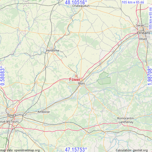
Fossé GPS coordinates[2]
47° 38' 0.564" North, 1° 17' 2.22" East
| Map corner | latitude | longitude |
|---|---|---|
| Upper-left | 48.10516°, | 0.58083° |
| Center: | 47.63349°, | 1.28395° |
| Lower-right: | 47.15753°, | 1.98708° |
| Map W x H: | 105.4×105.4 km | = 65.5×65.5mi |
| max Lat: | 51.07786° ⇑46.8% North |
| Fossé: | 47.63349° |
| min Lat: | ⇓53.2% South 41.3874° |
| min Long | Fossé | max Long |
| -5.08615° | 1.28395° | 9.52242° |
| W 34.2%⇐ | ⇒65.8% E |
Elevation
Elevation of Fossé is 114 m = 374 ft, and this is 79.7 m = 261 ft below average elevation for this country.
| Max E: |
2333 m = 7654 ft | 55.9% |
| Avg. | 193.7 m = 635 ft | |
| Fossé | 114 m = 374 ft | |
Min E: |
-1 m = -3 ft | 44.1% |
See also: France elevation on elevation.city.
Geographical zone
Fossé is located in North temperate zone (between Tropic of Cancer and the Arctic Circle). Distance of this North polar circle is 2104.8 km =1307.9 mi to North.| Distance of | km | miles | from Fossé |
|---|---|---|---|
| North Pole | 4710.7 | 2927.1 | to North |
| Arctic Circle | 2104.8 | 1307.9 | to North |
| Tropic Cancer | 2690.4 | 1671.7 | to South |
| Equator | 5296.3 | 3291 | to South |


Nearby cities:
15 places around Fossé: (largest is in red/bold)
• Averdon
5.7 km =3.5 mi,  8°
8°
• Blois
5.5 km =3.4 mi,  142°
142°
• La Chapelle-Vendômoise
5.4 km =3.4 mi,  321°
321°
• La Chaussée-Saint-Victor
6.6 km =4.1 mi,  107°
107°
• Landes-le-Gaulois
7.8 km =4.8 mi,  287°
287°
• Marolles
2.4 km =1.5 mi,  46°
46°
• Molineuf
8 km =5 mi,  218°
218°
• Orchaise
8 km =5 mi,  233°
233°
• Saint-Denis-sur-Loire
7.8 km =4.8 mi,  97°
97°
• Saint-Gervais-la-Forêt
9.1 km =5.7 mi, 144°
• Saint-Lubin-en-Vergonnois
4.4 km =2.7 mi,  239°
239°
• Saint-Sulpice-de-Pommeray
3.9 km =2.4 mi,  199°
199°
• Villebarou
3.1 km =1.9 mi, 111°
• Villerbon
7.4 km =4.6 mi,  63°
63°
• Vineuil
8.8 km =5.5 mi,  128°
128°
Sources, notices
• [Note1] Compared only with cities in France existing in our database
• [Src1] Map data: © OpenStreetMap contributors (CC-BY-SA)
• [Src2] Other city data from geonames.org with taken over terms of usage.
• [Src3] Geographical zone / Annual Mean Temperature by Robert A. Rohde @ Wikipedia
