Villennes-sur-Seine geodata
Villennes-sur-Seine (Île-de-France) is a populated place; located in France in Europe/Paris (GMT+2) time zone. With population of 5,070 people, there are 1945 cities with bigger population in this country. Compared to other cities in France, 78.4% of cities are located further ↓South; 57.3% of cities are located further →East and 56.9% of cities have higher elevation than Villennes-sur-Seine. Note1
Administrative division(s):
- Level 1: Île-de-France
- Level 2: Yvelines
- Level 3: Arrondissement de Saint-Germain-en-Laye
- Level 4: Villennes-sur-Seine


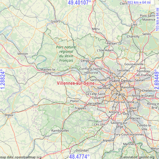
Villennes-sur-Seine GPS coordinates[2]
48° 56' 28.932" North, 1° 59' 28.932" East
| Map corner | latitude | longitude |
|---|---|---|
| Upper-left | 49.40107°, | 1.28824° |
| Center: | 48.94137°, | 1.99137° |
| Lower-right: | 48.4774°, | 2.69449° |
| Map W x H: | 102.7×102.7 km | = 63.8×63.8mi |
| max Lat: | 51.07786° ⇑21.6% North |
| Villennes-sur-Seine: | 48.94137° |
| min Lat: | ⇓78.4% South 41.3874° |
| min Long | Villennes-sur-S | max Long |
| -5.08615° | 1.99137° | 9.52242° |
| W 42.7%⇐ | ⇒57.3% E |
Elevation
Elevation of Villennes-sur-Seine is 111 m = 364 ft, and this is 82.7 m = 271 ft below average elevation for this country.
| Max E: |
2333 m = 7654 ft | 56.9% |
| Avg. | 193.7 m = 635 ft | |
| Villennes-sur-Seine | 111 m = 364 ft | |
Min E: |
-1 m = -3 ft | 43.1% |
See also: France elevation on elevation.city.
Geographical zone
Villennes-sur-Seine is located in North temperate zone (between Tropic of Cancer and the Arctic Circle). Distance of this North polar circle is 1959.4 km =1217.5 mi to North.| Distance of | km | miles | from Villennes-sur-Seine |
|---|---|---|---|
| North Pole | 4565.3 | 2836.7 | to North |
| Arctic Circle | 1959.4 | 1217.5 | to North |
| Tropic Cancer | 2835.9 | 1762.1 | to South |
| Equator | 5441.8 | 3381.4 | to South |


Nearby cities:
15 places around Villennes-sur-Seine: (largest is in red/bold)
• Achères
6.1 km =3.8 mi,  68°
68°
• Aigremont
4.6 km =2.9 mi,  153°
153°
• Carrières-sous-Poissy
3.7 km =2.3 mi,  75°
75°
• Chambourcy
5.3 km =3.3 mi,  136°
136°
• Chanteloup-les-Vignes
4.9 km =3 mi,  37°
37°
• Chapet
5.1 km =3.2 mi,  303°
303°
• Ecquevilly
5.1 km =3.2 mi,  283°
283°
• Les Alluets-le-Roi
6.2 km =3.9 mi,  240°
240°
• Morainvilliers
4.3 km =2.7 mi,  251°
251°
• Médan
1.6 km =1 mi,  9°
9°
• Orgeval
2.4 km =1.5 mi,  204°
204°
• Poissy
4.5 km =2.8 mi,  107°
107°
• Triel-sur-Seine
4.3 km =2.7 mi,  15°
15°
• Verneuil-sur-Seine
4.1 km =2.5 mi,  331°
331°
• Vernouillet
3.4 km =2.1 mi,  347°
347°
Sources, notices
• [Note1] Compared only with cities in France existing in our database
• [Src1] Map data: © OpenStreetMap contributors (CC-BY-SA)
• [Src2] Other city data from geonames.org with taken over terms of usage.
• [Src3] Geographical zone / Annual Mean Temperature by Robert A. Rohde @ Wikipedia
