Achères geodata
Achères (Île-de-France) is a populated place; located in France in Europe/Paris (GMT+2) time zone. With population of 22,555 people, there are 398 cities with bigger population in this country. Compared to other cities in France, 78.8% of cities are located further ↓South; 56.2% of cities are located further →East and 90.3% of cities have higher elevation than Achères. Note1
Administrative division(s):
- Level 1: Île-de-France
- Level 2: Yvelines
- Level 3: Arrondissement de Saint-Germain-en-Laye
- Level 4: Achères


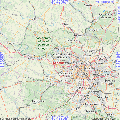
Achères GPS coordinates[2]
48° 57' 40.14" North, 2° 4' 7.752" East
| Map corner | latitude | longitude |
|---|---|---|
| Upper-left | 49.42067°, | 1.36569° |
| Center: | 48.96115°, | 2.06882° |
| Lower-right: | 48.49736°, | 2.77194° |
| Map W x H: | 102.7×102.7 km | = 63.8×63.8mi |
| max Lat: | 51.07786° ⇑21.2% North |
| Achères: | 48.96115° |
| min Lat: | ⇓78.8% South 41.3874° |
| min Long | Achères | max Long |
| -5.08615° | 2.06882° | 9.52242° |
| W 43.8%⇐ | ⇒56.2% E |
Elevation
Elevation of Achères is 29 m = 95 ft, and this is 164.7 m = 540 ft below average elevation for this country.
| Max E: |
2333 m = 7654 ft | 90.3% |
| Avg. | 193.7 m = 635 ft | |
| Achères | 29 m = 95 ft | |
Min E: |
-1 m = -3 ft | 9.7% |
See also: France elevation on elevation.city.
Geographical zone
Achères is located in North temperate zone (between Tropic of Cancer and the Arctic Circle). Distance of this North polar circle is 1957.2 km =1216.1 mi to North.| Distance of | km | miles | from Achères |
|---|---|---|---|
| North Pole | 4563.1 | 2835.4 | to North |
| Arctic Circle | 1957.2 | 1216.1 | to North |
| Tropic Cancer | 2838.1 | 1763.5 | to South |
| Equator | 5444 | 3382.7 | to South |


Nearby cities:
15 places around Achères: (largest is in red/bold)
• Andrésy
2.5 km =1.6 mi,  339°
339°
• Carrières-sous-Poissy
2.4 km =1.5 mi,  237°
237°
• Chambourcy
6.4 km =4 mi,  198°
198°
• Chanteloup-les-Vignes
3.1 km =1.9 mi,  302°
302°
• Conflans-Sainte-Honorine
4.9 km =3 mi,  24°
24°
• Jouy-le-Moutier
5.9 km =3.7 mi, 339°
• Le Mesnil-le-Roi
4.9 km =3 mi,  121°
121°
• Maisons-Laffitte
5.7 km =3.5 mi,  99°
99°
• Maurecourt
3.9 km =2.4 mi,  352°
352°
• Médan
5.4 km =3.4 mi,  263°
263°
• Neuville-sur-Oise
6.2 km =3.9 mi,  358°
358°
• Poissy
3.8 km =2.4 mi, 201°
• Triel-sur-Seine
4.9 km =3 mi,  292°
292°
• Vernouillet
6.5 km =4 mi,  280°
280°
• Villennes-sur-Seine
6.1 km =3.8 mi,  248°
248°
Sources, notices
• [Note1] Compared only with cities in France existing in our database
• [Src1] Map data: © OpenStreetMap contributors (CC-BY-SA)
• [Src2] Other city data from geonames.org with taken over terms of usage.
• [Src3] Geographical zone / Annual Mean Temperature by Robert A. Rohde @ Wikipedia
