Carrières-sous-Poissy geodata
Carrières-sous-Poissy (Île-de-France) is a populated place; located in France in Europe/Paris (GMT+2) time zone. With population of 15,465 people, there are 625 cities with bigger population in this country. Compared to other cities in France, 78.5% of cities are located further ↓South; 56.6% of cities are located further →East and 87.8% of cities have higher elevation than Carrières-sous-Poissy. Note1
Administrative division(s):
- Level 1: Île-de-France
- Level 2: Yvelines
- Level 3: Arrondissement de Saint-Germain-en-Laye
- Level 4: Carrières-sous-Poissy
Current local time in Carrières-sous-Poissy:
04:30 AM, WednesdayDifference from your time zone: hours


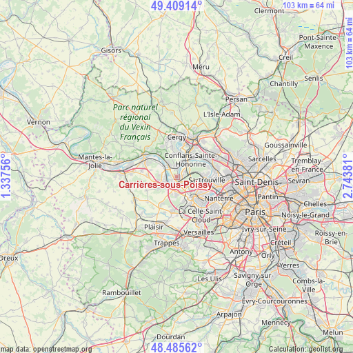
Carrières-sous-Poissy GPS coordinates[2]
48° 56' 58.272" North, 2° 2' 26.448" East
| Map corner | latitude | longitude |
|---|---|---|
| Upper-left | 49.40914°, | 1.33756° |
| Center: | 48.94952°, | 2.04068° |
| Lower-right: | 48.48562°, | 2.74381° |
| Map W x H: | 102.7×102.7 km | = 63.8×63.8mi |
| max Lat: | 51.07786° ⇑21.5% North |
| Carrières-sous-Poissy: | 48.94952° |
| min Lat: | ⇓78.5% South 41.3874° |
| min Long | Carrières-sous | max Long |
| -5.08615° | 2.04068° | 9.52242° |
| W 43.4%⇐ | ⇒56.6% E |
Elevation
Elevation of Carrières-sous-Poissy is 35 m = 115 ft, and this is 158.7 m = 521 ft below average elevation for this country.
| Max E: |
2333 m = 7654 ft | 87.8% |
| Avg. | 193.7 m = 635 ft | |
| Carrières-sous-Poissy | 35 m = 115 ft | |
Min E: |
-1 m = -3 ft | 12.2% |
See also: France elevation on elevation.city.
Geographical zone
Carrières-sous-Poissy is located in North temperate zone (between Tropic of Cancer and the Arctic Circle). Distance of this North polar circle is 1958.5 km =1217 mi to North.| Distance of | km | miles | from Carrières-sous-Poissy |
|---|---|---|---|
| North Pole | 4564.4 | 2836.2 | to North |
| Arctic Circle | 1958.5 | 1217 | to North |
| Tropic Cancer | 2836.8 | 1762.7 | to South |
| Equator | 5442.7 | 3381.9 | to South |


Nearby cities:
15 places around Carrières-sous-Poissy: (largest is in red/bold)
• Achères
2.4 km =1.5 mi,  57°
57°
• Aigremont
5.2 km =3.2 mi,  197°
197°
• Andrésy
3.8 km =2.4 mi,  17°
17°
• Chambourcy
4.8 km =3 mi,  179°
179°
• Chanteloup-les-Vignes
3 km =1.9 mi,  348°
348°
• Jouy-le-Moutier
6.8 km =4.2 mi,  359°
359°
• Le Mesnil-le-Roi
6.3 km =3.9 mi,  101°
101°
• Maurecourt
5.4 km =3.4 mi, 16°
• Médan
3.4 km =2.1 mi,  281°
281°
• Orgeval
5.5 km =3.4 mi,  235°
235°
• Poissy
2.4 km =1.5 mi,  164°
164°
• Triel-sur-Seine
4 km =2.5 mi,  322°
322°
• Verneuil-sur-Seine
6.2 km =3.9 mi,  296°
296°
• Vernouillet
5 km =3.1 mi, 299°
• Villennes-sur-Seine
3.7 km =2.3 mi,  255°
255°
Sources, notices
• [Note1] Compared only with cities in France existing in our database
• [Src1] Map data: © OpenStreetMap contributors (CC-BY-SA)
• [Src2] Other city data from geonames.org with taken over terms of usage.
• [Src3] Geographical zone / Annual Mean Temperature by Robert A. Rohde @ Wikipedia
