Othis geodata
Othis (Île-de-France) is a populated place; located in France in Europe/Paris (GMT+2) time zone. With population of 7,084 people, there are 1374 cities with bigger population in this country. Compared to other cities in France, 81.5% of cities are located further ↓South; 53.1% of cities are located further ←West and 56.9% of cities have higher elevation than Othis. Note1
Administrative division(s):
- Level 1: Île-de-France
- Level 2: Seine-et-Marne
- Level 3: Arrondissement de Meaux
- Level 4: Othis


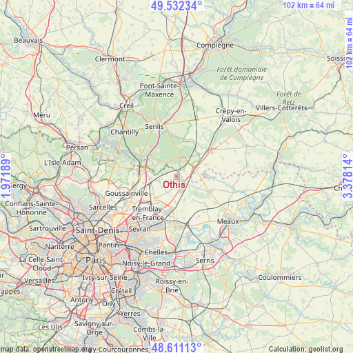
Othis GPS coordinates[2]
49° 4' 25.932" North, 2° 40' 30.072" East
| Map corner | latitude | longitude |
|---|---|---|
| Upper-left | 49.53234°, | 1.97189° |
| Center: | 49.07387°, | 2.67502° |
| Lower-right: | 48.61113°, | 3.37814° |
| Map W x H: | 102.4×102.4 km | = 63.6×63.6mi |
| max Lat: | 51.07786° ⇑18.5% North |
| Othis: | 49.07387° |
| min Lat: | ⇓81.5% South 41.3874° |
| min Long | Othis | max Long |
| -5.08615° | 2.67502° | 9.52242° |
| W 53.1%⇐ | ⇒46.9% E |
Elevation
Elevation of Othis is 111 m = 364 ft, and this is 82.7 m = 271 ft below average elevation for this country.
| Max E: |
2333 m = 7654 ft | 56.9% |
| Avg. | 193.7 m = 635 ft | |
| Othis | 111 m = 364 ft | |
Min E: |
-1 m = -3 ft | 43.1% |
See also: France elevation on elevation.city.
Geographical zone
Othis is located in North temperate zone (between Tropic of Cancer and the Arctic Circle). Distance of this North polar circle is 1944.7 km =1208.4 mi to North.| Distance of | km | miles | from Othis |
|---|---|---|---|
| North Pole | 4550.6 | 2827.6 | to North |
| Arctic Circle | 1944.7 | 1208.4 | to North |
| Tropic Cancer | 2850.6 | 1771.3 | to South |
| Equator | 5456.5 | 3390.5 | to South |


Nearby cities:
15 places around Othis: (largest is in red/bold)
• Dammartin-en-Goële
2.2 km =1.4 mi,  174°
174°
• Ermenonville
6.1 km =3.8 mi,  15°
15°
• Juilly
7 km =4.3 mi,  161°
161°
• Lagny-le-Sec
5.3 km =3.3 mi,  73°
73°
• Le Plessis-Belleville
6.4 km =4 mi, 68°
• Longperrier
2.9 km =1.8 mi,  193°
193°
• Montgé-en-Goële
7.1 km =4.4 mi,  129°
129°
• Moussy-le-Neuf
5.4 km =3.4 mi,  258°
258°
• Moussy-le-Vieux
4.7 km =2.9 mi,  230°
230°
• Plailly
7.3 km =4.5 mi,  296°
296°
• Rouvres
3.3 km =2.1 mi,  112°
112°
• Saint-Mard
4.4 km =2.7 mi, 159°
• Thieux
7.4 km =4.6 mi,  181°
181°
• Ver-sur-Launette
3.5 km =2.2 mi,  10°
10°
• Villeneuve-sous-Dammartin
5 km =3.1 mi,  209°
209°
Sources, notices
• [Note1] Compared only with cities in France existing in our database
• [Src1] Map data: © OpenStreetMap contributors (CC-BY-SA)
• [Src2] Other city data from geonames.org with taken over terms of usage.
• [Src3] Geographical zone / Annual Mean Temperature by Robert A. Rohde @ Wikipedia
