Le Mesnil-Amelot geodata
Le Mesnil-Amelot (Île-de-France) is a populated place; located in France in Europe/Paris (GMT+2) time zone. With population of 767 people, there are 10982 cities with bigger population in this country. Compared to other cities in France, 80.1% of cities are located further ↓South; 52% of cities are located further ←West and 59.4% of cities have higher elevation than Le Mesnil-Amelot. Note1
Administrative division(s):
- Level 1: Île-de-France
- Level 2: Seine-et-Marne
- Level 3: Arrondissement de Meaux
- Level 4: Le Mesnil-Amelot


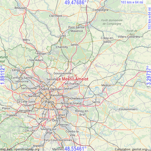
Le Mesnil-Amelot GPS coordinates[2]
49° 1' 4.332" North, 2° 35' 39.3" East
| Map corner | latitude | longitude |
|---|---|---|
| Upper-left | 49.47686°, | 1.89112° |
| Center: | 49.01787°, | 2.59425° |
| Lower-right: | 48.55461°, | 3.29737° |
| Map W x H: | 102.5×102.5 km | = 63.7×63.7mi |
| max Lat: | 51.07786° ⇑19.9% North |
| Le Mesnil-Amelot: | 49.01787° |
| min Lat: | ⇓80.1% South 41.3874° |
| min Long | Le Mesnil-Amelo | max Long |
| -5.08615° | 2.59425° | 9.52242° |
| W 52%⇐ | ⇒48% E |
Elevation
Elevation of Le Mesnil-Amelot is 104 m = 341 ft, and this is 89.7 m = 294 ft below average elevation for this country.
| Max E: |
2333 m = 7654 ft | 59.4% |
| Avg. | 193.7 m = 635 ft | |
| Le Mesnil-Amelot | 104 m = 341 ft | |
Min E: |
-1 m = -3 ft | 40.6% |
See also: France elevation on elevation.city.
Geographical zone
Le Mesnil-Amelot is located in North temperate zone (between Tropic of Cancer and the Arctic Circle). Distance of this North polar circle is 1950.9 km =1212.2 mi to North.| Distance of | km | miles | from Le Mesnil-Amelot |
|---|---|---|---|
| North Pole | 4556.8 | 2831.5 | to North |
| Arctic Circle | 1950.9 | 1212.2 | to North |
| Tropic Cancer | 2844.4 | 1767.4 | to South |
| Equator | 5450.3 | 3386.7 | to South |


Nearby cities:
15 places around Le Mesnil-Amelot: (largest is in red/bold)
• Compans
5.7 km =3.5 mi,  116°
116°
• Dammartin-en-Goële
7.3 km =4.5 mi,  56°
56°
• Longperrier
6.2 km =3.9 mi, 56°
• Louvres
7.2 km =4.5 mi,  294°
294°
• Mitry-Mory
4.2 km =2.6 mi,  156°
156°
• Moussy-le-Neuf
5.2 km =3.2 mi,  6°
6°
• Moussy-le-Vieux
3.9 km =2.4 mi,  34°
34°
• Roissy-en-France
5.8 km =3.6 mi,  255°
255°
• Saint-Mard
7.7 km =4.8 mi,  74°
74°
• Thieux
5.8 km =3.6 mi,  101°
101°
• Tremblay-en-France
7.8 km =4.8 mi,  193°
193°
• Villeneuve-sous-Dammartin
3.9 km =2.4 mi, 60°
• Villepinte
7.7 km =4.8 mi,  215°
215°
• Villeron
5.8 km =3.6 mi,  319°
319°
• Vémars
6.1 km =3.8 mi,  340°
340°
Sources, notices
• [Note1] Compared only with cities in France existing in our database
• [Src1] Map data: © OpenStreetMap contributors (CC-BY-SA)
• [Src2] Other city data from geonames.org with taken over terms of usage.
• [Src3] Geographical zone / Annual Mean Temperature by Robert A. Rohde @ Wikipedia
