Villeneuve-la-Comtesse geodata
Villeneuve-la-Comtesse (Nouvelle-Aquitaine) is a populated place; located in France in Europe/Paris (GMT+2) time zone. With population of 776 people, there are 10868 cities with bigger population in this country. Compared to other cities in France, 65.1% of cities are located further ↑North; 83.5% of cities are located further →East and 81.5% of cities have higher elevation than Villeneuve-la-Comtesse. Note1
Administrative division(s):
- Level 1: Nouvelle-Aquitaine
- Level 2: Charente-Maritime
- Level 3: Arrondissement de Saint-Jean-d'Angély
- Level 4: Villeneuve-la-Comtesse
Current local time in Villeneuve-la-Comtesse:
12:45 PM, SaturdayDifference from your time zone: hours


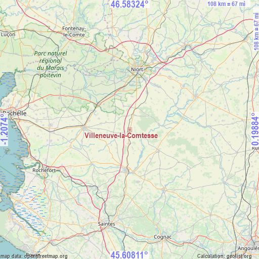
Villeneuve-la-Comtesse GPS coordinates[2]
46° 5' 52.188" North, 0° 30' 15.408" West
| Map corner | latitude | longitude |
|---|---|---|
| Upper-left | 46.58324°, | -1.2074° |
| Center: | 46.09783°, | -0.50428° |
| Lower-right: | 45.60811°, | 0.19884° |
| Map W x H: | 108.4×108.4 km | = 67.4×67.4mi |
| max Lat: | 51.07786° ⇑65.1% North |
| Villeneuve-la-Comtesse: | 46.09783° |
| min Lat: | ⇓34.9% South 41.3874° |
| min Long | Villeneuve-la-C | max Long |
| -5.08615° | -0.50428° | 9.52242° |
| W 16.5%⇐ | ⇒83.5% E |
Elevation
Elevation of Villeneuve-la-Comtesse is 51 m = 167 ft, and this is 142.7 m = 468 ft below average elevation for this country.
| Max E: |
2333 m = 7654 ft | 81.5% |
| Avg. | 193.7 m = 635 ft | |
| Villeneuve-la-Comtesse | 51 m = 167 ft | |
Min E: |
-1 m = -3 ft | 18.5% |
See also: France elevation on elevation.city.
Geographical zone
Villeneuve-la-Comtesse is located in North temperate zone (between Tropic of Cancer and the Arctic Circle). Distance of this North polar circle is 2275.6 km =1414 mi to North.| Distance of | km | miles | from Villeneuve-la-Comtesse |
|---|---|---|---|
| North Pole | 4881.5 | 3033.2 | to North |
| Arctic Circle | 2275.6 | 1414 | to North |
| Tropic Cancer | 2519.7 | 1565.7 | to South |
| Equator | 5125.6 | 3184.9 | to South |


Nearby cities:
15 places around Villeneuve-la-Comtesse: (largest is in red/bold)
• Aulnay
14.8 km =9.2 mi,  125°
125°
• Beauvoir-sur-Niort
9.6 km =6 mi,  14°
14°
• Bernay-Saint-Martin
9.3 km =5.8 mi,  248°
248°
• Chizé
12.3 km =7.6 mi,  80°
80°
• Granzay-Gript
13.3 km =8.3 mi, 6°
• La Foye-Monjault
10.2 km =6.3 mi,  345°
345°
• La Vergne
15.5 km =9.6 mi,  197°
197°
• Landes
13.7 km =8.5 mi,  211°
211°
• Loulay
5.8 km =3.6 mi,  184°
184°
• Marigny
12.9 km =8 mi,  30°
30°
• Marsais
8 km =5 mi,  292°
292°
• Prissé-la-Charrière
5.8 km =3.6 mi,  3°
3°
• Saint-Saturnin-du-Bois
13.6 km =8.5 mi, 289°
• Usseau
10.3 km =6.4 mi,  325°
325°
• Vallans
13.7 km =8.5 mi,  344°
344°
Sources, notices
• [Note1] Compared only with cities in France existing in our database
• [Src1] Map data: © OpenStreetMap contributors (CC-BY-SA)
• [Src2] Other city data from geonames.org with taken over terms of usage.
• [Src3] Geographical zone / Annual Mean Temperature by Robert A. Rohde @ Wikipedia
