Aulnay geodata
Aulnay (Nouvelle-Aquitaine) is a populated place; located in France in Europe/Paris (GMT+2) time zone. With population of 1,620 people, there are 5764 cities with bigger population in this country. Compared to other cities in France, 66% of cities are located further ↑North; 81.3% of cities are located further →East and 78.6% of cities have higher elevation than Aulnay. Note1
Administrative division(s):
- Level 1: Nouvelle-Aquitaine
- Level 2: Charente-Maritime
- Level 3: Arrondissement de Saint-Jean-d'Angély
- Level 4: Aulnay


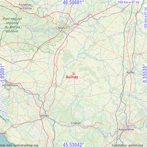
Aulnay GPS coordinates[2]
46° 1' 14.952" North, 0° 20' 52.008" West
| Map corner | latitude | longitude |
|---|---|---|
| Upper-left | 46.50691°, | -1.05091° |
| Center: | 46.02082°, | -0.34778° |
| Lower-right: | 45.53042°, | 0.35535° |
| Map W x H: | 108.6×108.6 km | = 67.5×67.5mi |
| max Lat: | 51.07786° ⇑66% North |
| Aulnay: | 46.02082° |
| min Lat: | ⇓34% South 41.3874° |
| min Long | Aulnay | max Long |
| -5.08615° | -0.34778° | 9.52242° |
| W 18.7%⇐ | ⇒81.3% E |
Elevation
Elevation of Aulnay is 58 m = 190 ft, and this is 135.7 m = 445 ft below average elevation for this country.
| Max E: |
2333 m = 7654 ft | 78.6% |
| Avg. | 193.7 m = 635 ft | |
| Aulnay | 58 m = 190 ft | |
Min E: |
-1 m = -3 ft | 21.4% |
See also: France elevation on elevation.city.
Geographical zone
Aulnay is located in North temperate zone (between Tropic of Cancer and the Arctic Circle). Distance of this North polar circle is 2284.1 km =1419.3 mi to North.| Distance of | km | miles | from Aulnay |
|---|---|---|---|
| North Pole | 4890 | 3038.5 | to North |
| Arctic Circle | 2284.1 | 1419.3 | to North |
| Tropic Cancer | 2511.1 | 1560.3 | to South |
| Equator | 5117 | 3179.6 | to South |


Nearby cities:
15 places around Aulnay: (largest is in red/bold)
• Aumagne
16.8 km =10.4 mi,  194°
194°
• Brioux-sur-Boutonne
16.6 km =10.3 mi,  35°
35°
• Chizé
10.6 km =6.6 mi,  0°
0°
• Fontenille-Saint-Martin-d'Entraigues
19.7 km =12.2 mi,  57°
57°
• La Brousse
14.5 km =9 mi,  184°
184°
• La Vergne
17.8 km =11.1 mi,  249°
249°
• Landes
19.5 km =12.1 mi,  260°
260°
• Les Touches-de-Périgny
14 km =8.7 mi,  153°
153°
• Loulay
12.8 km =8 mi,  282°
282°
• Matha
17.1 km =10.6 mi,  172°
172°
• Néré
10.1 km =6.3 mi,  121°
121°
• Prissé-la-Charrière
18.6 km =11.6 mi,  320°
320°
• Saint-Jean-d’Angély
15.9 km =9.9 mi,  237°
237°
• Varaize
12.4 km =7.7 mi,  208°
208°
• Villeneuve-la-Comtesse
14.8 km =9.2 mi,  305°
305°
Sources, notices
• [Note1] Compared only with cities in France existing in our database
• [Src1] Map data: © OpenStreetMap contributors (CC-BY-SA)
• [Src2] Other city data from geonames.org with taken over terms of usage.
• [Src3] Geographical zone / Annual Mean Temperature by Robert A. Rohde @ Wikipedia
