Villemoustaussou geodata
Villemoustaussou (Occitanie) is a populated place; located in France in Europe/Paris (GMT+2) time zone. With population of 2,943 people, there are 3312 cities with bigger population in this country. Compared to other cities in France, 96.5% of cities are located further ↑North; 51.6% of cities are located further →East and 55.6% of cities have higher elevation than Villemoustaussou. Note1
Administrative division(s):
- Level 1: Occitanie
- Level 2: Département de l'Aude
- Level 3: Arrondissement de Carcassonne
- Level 4: Villemoustaussou


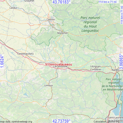
Villemoustaussou GPS coordinates[2]
43° 15' 6.696" North, 2° 21' 55.872" East
| Map corner | latitude | longitude |
|---|---|---|
| Upper-left | 43.76183°, | 1.6624° |
| Center: | 43.25186°, | 2.36552° |
| Lower-right: | 42.73759°, | 3.06865° |
| Map W x H: | 113.9×113.9 km | = 70.8×70.8mi |
| max Lat: | 51.07786° ⇑96.5% North |
| Villemoustaussou: | 43.25186° |
| min Lat: | ⇓3.5% South 41.3874° |
| min Long | Villemoustausso | max Long |
| -5.08615° | 2.36552° | 9.52242° |
| W 48.4%⇐ | ⇒51.6% E |
Elevation
Elevation of Villemoustaussou is 115 m = 377 ft, and this is 78.7 m = 258 ft below average elevation for this country.
| Max E: |
2333 m = 7654 ft | 55.6% |
| Avg. | 193.7 m = 635 ft | |
| Villemoustaussou | 115 m = 377 ft | |
Min E: |
-1 m = -3 ft | 44.4% |
See also: France elevation on elevation.city.
Geographical zone
Villemoustaussou is located in North temperate zone (between Tropic of Cancer and the Arctic Circle). Distance of this Northern Tropic circle is 2203.2 km =1369 mi to South.| Distance of | km | miles | from Villemoustaussou |
|---|---|---|---|
| North Pole | 5197.9 | 3229.8 | to North |
| Arctic Circle | 2592 | 1610.6 | to North |
| Tropic Cancer | 2203.2 | 1369 | to South |
| Equator | 4809.2 | 2988.3 | to South |


Nearby cities:
15 places around Villemoustaussou: (largest is in red/bold)
• Berriac
5.7 km =3.5 mi,  139°
139°
• Carcassonne
4.4 km =2.7 mi,  194°
194°
• Caux-et-Sauzens
9.4 km =5.8 mi,  251°
251°
• Cavanac
9.8 km =6.1 mi,  197°
197°
• Cazilhac
7.8 km =4.8 mi,  182°
182°
• Conques-sur-Orbiel
4.5 km =2.8 mi,  68°
68°
• Malves-en-Minervois
6.8 km =4.2 mi,  91°
91°
• Palaja
8.8 km =5.5 mi,  169°
169°
• Pennautier
3.8 km =2.4 mi,  258°
258°
• Pezens
7.8 km =4.8 mi,  272°
272°
• Trèbes
7.7 km =4.8 mi,  126°
126°
• Ventenac-Cabardès
6.7 km =4.2 mi,  283°
283°
• Villalier
3.8 km =2.4 mi,  82°
82°
• Villegailhenc
2.1 km =1.3 mi,  334°
334°
• Villegly
7.2 km =4.5 mi,  58°
58°
Sources, notices
• [Note1] Compared only with cities in France existing in our database
• [Src1] Map data: © OpenStreetMap contributors (CC-BY-SA)
• [Src2] Other city data from geonames.org with taken over terms of usage.
• [Src3] Geographical zone / Annual Mean Temperature by Robert A. Rohde @ Wikipedia
