Carcassonne geodata
Carcassonne (Occitanie) is a seat of a second-order administrative division; located in France in Europe/Paris (GMT+2) time zone. With population of 49,600 people, there are 126 cities with bigger population in this country. Compared to other cities in France, 97% of cities are located further ↑North; 51.8% of cities are located further →East and 59.7% of cities have higher elevation than Carcassonne. Note1
Administrative division(s):
- Level 1: Occitanie
- Level 2: Département de l'Aude
- Level 3: Arrondissement de Carcassonne
- Level 4: Carcassonne


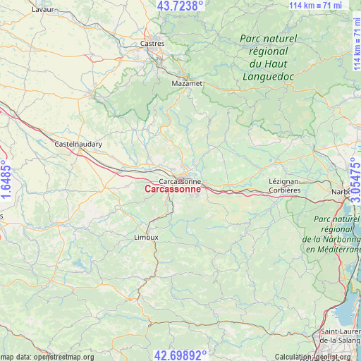
Carcassonne GPS coordinates[2]
43° 12' 48.636" North, 2° 21' 5.832" East
| Map corner | latitude | longitude |
|---|---|---|
| Upper-left | 43.7238°, | 1.6485° |
| Center: | 43.21351°, | 2.35162° |
| Lower-right: | 42.69892°, | 3.05475° |
| Map W x H: | 114×114 km | = 70.8×70.8mi |
| max Lat: | 51.07786° ⇑97% North |
| Carcassonne: | 43.21351° |
| min Lat: | ⇓3% South 41.3874° |
| min Long | Carcassonne | max Long |
| -5.08615° | 2.35162° | 9.52242° |
| W 48.2%⇐ | ⇒51.8% E |
Elevation
Elevation of Carcassonne is 103 m = 338 ft, and this is 90.7 m = 298 ft below average elevation for this country.
| Max E: |
2333 m = 7654 ft | 59.7% |
| Avg. | 193.7 m = 635 ft | |
| Carcassonne | 103 m = 338 ft | |
Min E: |
-1 m = -3 ft | 40.3% |
See also: Carcassonne elevation on elevation.city.
Geographical zone
Carcassonne is located in North temperate zone (between Tropic of Cancer and the Arctic Circle). Distance of this Northern Tropic circle is 2199 km =1366.4 mi to South.| Distance of | km | miles | from Carcassonne |
|---|---|---|---|
| North Pole | 5202.2 | 3232.5 | to North |
| Arctic Circle | 2596.3 | 1613.3 | to North |
| Tropic Cancer | 2199 | 1366.4 | to South |
| Equator | 4804.9 | 2985.6 | to South |


Nearby cities:
15 places around Carcassonne: (largest is in red/bold)
• Berriac
4.8 km =3 mi,  91°
91°
• Caux-et-Sauzens
7.9 km =4.9 mi,  279°
279°
• Cavanac
5.4 km =3.4 mi,  200°
200°
• Cazilhac
3.6 km =2.2 mi,  167°
167°
• Conques-sur-Orbiel
7.9 km =4.9 mi,  41°
41°
• Couffoulens
7.4 km =4.6 mi,  209°
209°
• Lavalette
7.5 km =4.7 mi,  244°
244°
• Leuc
7.7 km =4.8 mi, 197°
• Palaja
5.2 km =3.2 mi,  148°
148°
• Pennautier
4.4 km =2.7 mi,  323°
323°
• Trèbes
7.3 km =4.5 mi, 92°
• Ventenac-Cabardès
8 km =5 mi, 317°
• Villalier
6.8 km =4.2 mi,  45°
45°
• Villegailhenc
6.1 km =3.8 mi,  2°
2°
• Villemoustaussou
4.4 km =2.7 mi,  14°
14°
Sources, notices
• [Note1] Compared only with cities in France existing in our database
• [Src1] Map data: © OpenStreetMap contributors (CC-BY-SA)
• [Src2] Other city data from geonames.org with taken over terms of usage.
• [Src3] Geographical zone / Annual Mean Temperature by Robert A. Rohde @ Wikipedia
