Villemomble geodata
Villemomble (Île-de-France) is a populated place; located in France in Europe/Paris (GMT+2) time zone. With population of 28,001 people, there are 304 cities with bigger population in this country. Compared to other cities in France, 77.2% of cities are located further ↓South; 50.6% of cities are located further ←West and 74.1% of cities have higher elevation than Villemomble. Note1
Administrative division(s):
- Level 1: Île-de-France
- Level 2: Seine-Saint-Denis
- Level 3: Arrondissement du Raincy
- Level 4: Villemomble


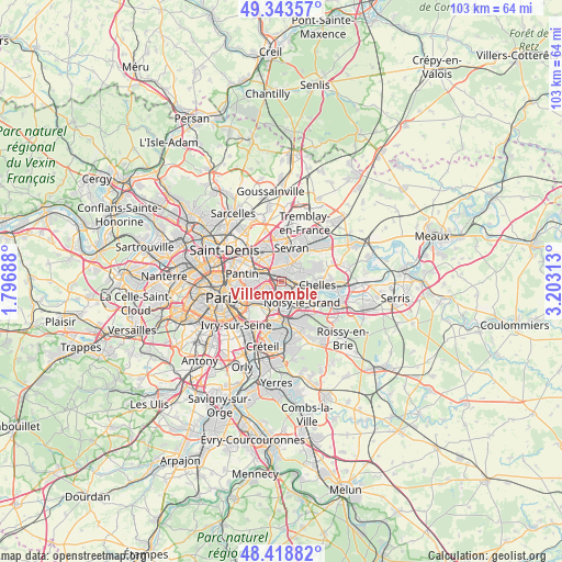
Villemomble GPS coordinates[2]
48° 52' 59.988" North, 2° 30' 0" East
| Map corner | latitude | longitude |
|---|---|---|
| Upper-left | 49.34357°, | 1.79688° |
| Center: | 48.88333°, | 2.5° |
| Lower-right: | 48.41882°, | 3.20313° |
| Map W x H: | 102.8×102.8 km | = 63.9×63.9mi |
| max Lat: | 51.07786° ⇑22.8% North |
| Villemomble: | 48.88333° |
| min Lat: | ⇓77.2% South 41.3874° |
| min Long | Villemomble | max Long |
| -5.08615° | 2.5° | 9.52242° |
| W 50.6%⇐ | ⇒49.4% E |
Elevation
Elevation of Villemomble is 69 m = 226 ft, and this is 124.7 m = 409 ft below average elevation for this country.
| Max E: |
2333 m = 7654 ft | 74.1% |
| Avg. | 193.7 m = 635 ft | |
| Villemomble | 69 m = 226 ft | |
Min E: |
-1 m = -3 ft | 25.9% |
See also: France elevation on elevation.city.
Geographical zone
Villemomble is located in North temperate zone (between Tropic of Cancer and the Arctic Circle). Distance of this North polar circle is 1965.9 km =1221.6 mi to North.| Distance of | km | miles | from Villemomble |
|---|---|---|---|
| North Pole | 4571.7 | 2840.7 | to North |
| Arctic Circle | 1965.9 | 1221.6 | to North |
| Tropic Cancer | 2829.4 | 1758.1 | to South |
| Equator | 5435.3 | 3377.3 | to South |


Nearby cities:
15 places around Villemomble: (largest is in red/bold)
• Bobigny
4.7 km =2.9 mi,  308°
308°
• Bondy
2.2 km =1.4 mi,  339°
339°
• Clichy-sous-Bois
4.9 km =3 mi,  52°
52°
• Fontenay-sous-Bois
3.5 km =2.2 mi,  201°
201°
• Gagny
2.4 km =1.5 mi,  90°
90°
• Le Perreux-sur-Marne
3.7 km =2.3 mi,  180°
180°
• Le Raincy
2.4 km =1.5 mi,  43°
43°
• Les Pavillons-sous-Bois
2.7 km =1.7 mi,  10°
10°
• Livry-Gargan
5.1 km =3.2 mi, 38°
• Montreuil
4.7 km =2.9 mi,  242°
242°
• Neuilly-Plaisance
2.3 km =1.4 mi,  168°
168°
• Neuilly-sur-Marne
4.9 km =3 mi,  132°
132°
• Noisy-le-Sec
2.7 km =1.7 mi,  289°
289°
• Romainville
4.8 km =3 mi,  272°
272°
• Rosny-sous-Bois
1.5 km =0.9 mi, 182°
Sources, notices
• [Note1] Compared only with cities in France existing in our database
• [Src1] Map data: © OpenStreetMap contributors (CC-BY-SA)
• [Src2] Other city data from geonames.org with taken over terms of usage.
• [Src3] Geographical zone / Annual Mean Temperature by Robert A. Rohde @ Wikipedia
