Les Pavillons-sous-Bois geodata
Les Pavillons-sous-Bois (Île-de-France) is a populated place; located in France in Europe/Paris (GMT+2) time zone. With population of 19,730 people, there are 467 cities with bigger population in this country. Compared to other cities in France, 77.7% of cities are located further ↓South; 50.7% of cities are located further ←West and 79.8% of cities have higher elevation than Les Pavillons-sous-Bois. Note1
Administrative division(s):
- Level 1: Île-de-France
- Level 2: Seine-Saint-Denis
- Level 3: Arrondissement du Raincy
- Level 4: Les Pavillons-sous-Bois
Current local time in Les Pavillons-sous-Bois:
12:33 AM, SaturdayDifference from your time zone: hours


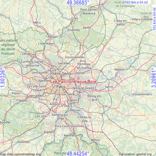
Les Pavillons-sous-Bois GPS coordinates[2]
48° 54' 24.588" North, 2° 30' 23.328" East
| Map corner | latitude | longitude |
|---|---|---|
| Upper-left | 49.36685°, | 1.80336° |
| Center: | 48.90683°, | 2.50648° |
| Lower-right: | 48.44254°, | 3.20961° |
| Map W x H: | 102.8×102.8 km | = 63.9×63.9mi |
| max Lat: | 51.07786° ⇑22.3% North |
| Les Pavillons-sous-Bois: | 48.90683° |
| min Lat: | ⇓77.7% South 41.3874° |
| min Long | Les Pavillons-s | max Long |
| -5.08615° | 2.50648° | 9.52242° |
| W 50.7%⇐ | ⇒49.3% E |
Elevation
Elevation of Les Pavillons-sous-Bois is 55 m = 180 ft, and this is 138.7 m = 455 ft below average elevation for this country.
| Max E: |
2333 m = 7654 ft | 79.8% |
| Avg. | 193.7 m = 635 ft | |
| Les Pavillons-sous-Bois | 55 m = 180 ft | |
Min E: |
-1 m = -3 ft | 20.2% |
See also: France elevation on elevation.city.
Geographical zone
Les Pavillons-sous-Bois is located in North temperate zone (between Tropic of Cancer and the Arctic Circle). Distance of this North polar circle is 1963.2 km =1219.9 mi to North.| Distance of | km | miles | from Les Pavillons-sous-Bois |
|---|---|---|---|
| North Pole | 4569.1 | 2839.1 | to North |
| Arctic Circle | 1963.2 | 1219.9 | to North |
| Tropic Cancer | 2832 | 1759.7 | to South |
| Equator | 5437.9 | 3379 | to South |


Nearby cities:
15 places around Les Pavillons-sous-Bois: (largest is in red/bold)
• Aulnay-sous-Bois
3.6 km =2.2 mi,  345°
345°
• Bobigny
4.1 km =2.5 mi,  274°
274°
• Bondy
1.4 km =0.9 mi,  245°
245°
• Clichy-sous-Bois
3.4 km =2.1 mi,  83°
83°
• Drancy
4.9 km =3 mi,  295°
295°
• Gagny
3.3 km =2.1 mi,  143°
143°
• Le Blanc-Mesnil
4.8 km =3 mi,  317°
317°
• Le Raincy
1.5 km =0.9 mi,  125°
125°
• Livry-Gargan
3 km =1.9 mi,  62°
62°
• Neuilly-Plaisance
4.8 km =3 mi,  180°
180°
• Noisy-le-Sec
3.5 km =2.2 mi,  240°
240°
• Rosny-sous-Bois
4.1 km =2.5 mi,  187°
187°
• Sevran
4.5 km =2.8 mi,  19°
19°
• Vaujours
5.4 km =3.4 mi, 61°
• Villemomble
2.7 km =1.7 mi, 190°
Sources, notices
• [Note1] Compared only with cities in France existing in our database
• [Src1] Map data: © OpenStreetMap contributors (CC-BY-SA)
• [Src2] Other city data from geonames.org with taken over terms of usage.
• [Src3] Geographical zone / Annual Mean Temperature by Robert A. Rohde @ Wikipedia
