Villemeux-sur-Eure geodata
Villemeux-sur-Eure (Centre) is a populated place; located in France in Europe/Paris (GMT+2) time zone. With population of 1,586 people, there are 5886 cities with bigger population in this country. Compared to other cities in France, 72.6% of cities are located further ↓South; 63.5% of cities are located further →East and 64% of cities have higher elevation than Villemeux-sur-Eure. Note1
Administrative division(s):
- Level 1: Centre
- Level 2: Département d'Eure-et-Loir
- Level 3: Arrondissement de Dreux
- Level 4: Villemeux-sur-Eure


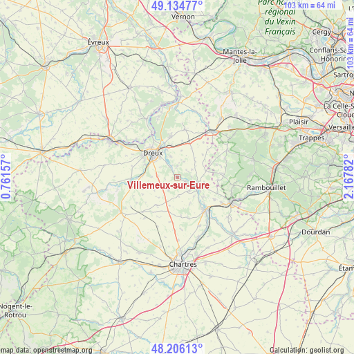
Villemeux-sur-Eure GPS coordinates[2]
48° 40' 21.324" North, 1° 27' 52.92" East
| Map corner | latitude | longitude |
|---|---|---|
| Upper-left | 49.13477°, | 0.76157° |
| Center: | 48.67259°, | 1.4647° |
| Lower-right: | 48.20613°, | 2.16782° |
| Map W x H: | 103.3×103.3 km | = 64.2×64.2mi |
| max Lat: | 51.07786° ⇑27.4% North |
| Villemeux-sur-Eure: | 48.67259° |
| min Lat: | ⇓72.6% South 41.3874° |
| min Long | Villemeux-sur-E | max Long |
| -5.08615° | 1.4647° | 9.52242° |
| W 36.5%⇐ | ⇒63.5% E |
Elevation
Elevation of Villemeux-sur-Eure is 92 m = 302 ft, and this is 101.7 m = 334 ft below average elevation for this country.
| Max E: |
2333 m = 7654 ft | 64% |
| Avg. | 193.7 m = 635 ft | |
| Villemeux-sur-Eure | 92 m = 302 ft | |
Min E: |
-1 m = -3 ft | 36% |
See also: France elevation on elevation.city.
Geographical zone
Villemeux-sur-Eure is located in North temperate zone (between Tropic of Cancer and the Arctic Circle). Distance of this North polar circle is 1989.3 km =1236.1 mi to North.| Distance of | km | miles | from Villemeux-sur-Eure |
|---|---|---|---|
| North Pole | 4595.2 | 2855.3 | to North |
| Arctic Circle | 1989.3 | 1236.1 | to North |
| Tropic Cancer | 2806 | 1743.6 | to South |
| Equator | 5411.9 | 3362.8 | to South |


Nearby cities:
15 places around Villemeux-sur-Eure: (largest is in red/bold)
• Broué
9.5 km =5.9 mi,  26°
26°
• Charpont
3.6 km =2.2 mi,  324°
324°
• Chaudon
2.6 km =1.6 mi,  114°
114°
• Cherisy
8.9 km =5.5 mi,  345°
345°
• Coulombs
6.4 km =4 mi, 110°
• Lormaye
5.7 km =3.5 mi,  116°
116°
• Luray
7.2 km =4.5 mi, 317°
• Marville-Moutiers-Brûlé
4.8 km =3 mi,  262°
262°
• Mézières-en-Drouais
6.4 km =4 mi,  332°
332°
• Nogent-le-Roi
5.5 km =3.4 mi, 120°
• Ouerre
3.1 km =1.9 mi,  1°
1°
• Sainte-Gemme-Moronval
8.2 km =5.1 mi, 333°
• Senantes
7.5 km =4.7 mi,  95°
95°
• Vernouillet
8.8 km =5.5 mi,  307°
307°
• Villiers-le-Morhier
9.3 km =5.8 mi,  128°
128°
Sources, notices
• [Note1] Compared only with cities in France existing in our database
• [Src1] Map data: © OpenStreetMap contributors (CC-BY-SA)
• [Src2] Other city data from geonames.org with taken over terms of usage.
• [Src3] Geographical zone / Annual Mean Temperature by Robert A. Rohde @ Wikipedia
