Albefeuille-Lagarde geodata
Albefeuille-Lagarde (Occitanie) is a populated place; located in France in Europe/Paris (GMT+2) time zone. With population of 694 people, there are 11888 cities with bigger population in this country. Compared to other cities in France, 86.7% of cities are located further ↑North; 66% of cities are located further →East and 69.7% of cities have higher elevation than Albefeuille-Lagarde. Note1
Administrative division(s):
- Level 1: Occitanie
- Level 2: Département du Tarn-et-Garonne
- Level 3: Arrondissement de Castelsarrasin
- Level 4: Albefeuille-Lagarde


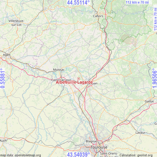
Albefeuille-Lagarde GPS coordinates[2]
44° 2' 52.512" North, 1° 15' 42.948" East
| Map corner | latitude | longitude |
|---|---|---|
| Upper-left | 44.55114°, | 0.55881° |
| Center: | 44.04792°, | 1.26193° |
| Lower-right: | 43.54039°, | 1.96506° |
| Map W x H: | 112.4×112.4 km | = 69.8×69.8mi |
| max Lat: | 51.07786° ⇑86.7% North |
| Albefeuille-Lagarde: | 44.04792° |
| min Lat: | ⇓13.3% South 41.3874° |
| min Long | Albefeuille-Lag | max Long |
| -5.08615° | 1.26193° | 9.52242° |
| W 34%⇐ | ⇒66% E |
Elevation
Elevation of Albefeuille-Lagarde is 79 m = 259 ft, and this is 114.7 m = 376 ft below average elevation for this country.
| Max E: |
2333 m = 7654 ft | 69.7% |
| Avg. | 193.7 m = 635 ft | |
| Albefeuille-Lagarde | 79 m = 259 ft | |
Min E: |
-1 m = -3 ft | 30.3% |
See also: France elevation on elevation.city.
Geographical zone
Albefeuille-Lagarde is located in North temperate zone (between Tropic of Cancer and the Arctic Circle). Distance of this Northern Tropic circle is 2291.8 km =1424.1 mi to South.| Distance of | km | miles | from Albefeuille-Lagarde |
|---|---|---|---|
| North Pole | 5109.4 | 3174.8 | to North |
| Arctic Circle | 2503.5 | 1555.6 | to North |
| Tropic Cancer | 2291.8 | 1424.1 | to South |
| Equator | 4897.7 | 3043.3 | to South |


Nearby cities:
15 places around Albefeuille-Lagarde: (largest is in red/bold)
• Bourret
13.9 km =8.6 mi,  212°
212°
• Bressols
10.8 km =6.7 mi,  145°
145°
• Castelsarrasin
12.4 km =7.7 mi,  266°
266°
• Escatalens
9.1 km =5.7 mi,  219°
219°
• Labastide-du-Temple
6.7 km =4.2 mi,  307°
307°
• Lacourt-Saint-Pierre
6.9 km =4.3 mi,  178°
178°
• Lafrançaise
9 km =5.6 mi,  349°
349°
• Lamothe-Capdeville
9.5 km =5.9 mi,  68°
68°
• Meauzac
4.8 km =3 mi,  338°
338°
• Montauban
8.8 km =5.5 mi,  111°
111°
• Montbeton
4.6 km =2.9 mi,  138°
138°
• Montech
10.3 km =6.4 mi,  193°
193°
• Puycornet
14.3 km =8.9 mi,  28°
28°
• Saint-Porquier
8.3 km =5.2 mi,  233°
233°
• Villemade
3.7 km =2.3 mi,  36°
36°
Sources, notices
• [Note1] Compared only with cities in France existing in our database
• [Src1] Map data: © OpenStreetMap contributors (CC-BY-SA)
• [Src2] Other city data from geonames.org with taken over terms of usage.
• [Src3] Geographical zone / Annual Mean Temperature by Robert A. Rohde @ Wikipedia
