Villars-sur-Var geodata
Villars-sur-Var (Provence-Alpes-Côte d'Azur) is a populated place; located in France in Europe/Paris (GMT+2) time zone. With population of 603 people, there are 13268 cities with bigger population in this country. Compared to other cities in France, 87.7% of cities are located further ↑North; 95.2% of cities are located further ←West and 89.5% of cities have lower elevation than Villars-sur-Var. Note1
Administrative division(s):
- Level 1: Provence-Alpes-Côte d'Azur
- Level 2: Alpes-Maritimes
- Level 3: Arrondissement de Nice
- Level 4: Villars-sur-Var


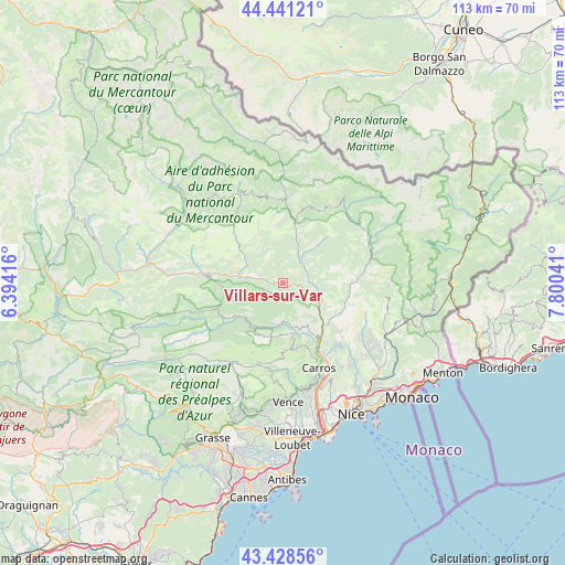
Villars-sur-Var GPS coordinates[2]
43° 56' 13.344" North, 7° 5' 50.244" East
| Map corner | latitude | longitude |
|---|---|---|
| Upper-left | 44.44121°, | 6.39416° |
| Center: | 43.93704°, | 7.09729° |
| Lower-right: | 43.42856°, | 7.80041° |
| Map W x H: | 112.6×112.6 km | = 70×70mi |
| max Lat: | 51.07786° ⇑87.7% North |
| Villars-sur-Var: | 43.93704° |
| min Lat: | ⇓12.3% South 41.3874° |
| min Long | Villars-sur-Var | max Long |
| -5.08615° | 7.09729° | 9.52242° |
| W 95.2%⇐ | ⇒4.8% E |
Elevation
Elevation of Villars-sur-Var is 416 m = 1365 ft, and this is 222.3 m = 729 ft above average elevation for this country.
| Max E: |
2333 m = 7654 ft | 10.5% |
| Villars-sur-Var | 416 m 1365 ft | |
| Avg. | 193.7 m = 635 ft | |
Min E: |
-1 m = -3 ft | 89.5% |
See also: France elevation on elevation.city.
Geographical zone
Villars-sur-Var is located in North temperate zone (between Tropic of Cancer and the Arctic Circle). Distance of this Northern Tropic circle is 2279.4 km =1416.4 mi to South.| Distance of | km | miles | from Villars-sur-Var |
|---|---|---|---|
| North Pole | 5121.7 | 3182.5 | to North |
| Arctic Circle | 2515.8 | 1563.2 | to North |
| Tropic Cancer | 2279.4 | 1416.4 | to South |
| Equator | 4885.3 | 3035.6 | to South |


Nearby cities:
15 places around Villars-sur-Var: (largest is in red/bold)
• Bonson
11.1 km =6.9 mi,  138°
138°
• Carros
17.6 km =10.9 mi,  155°
155°
• Clans
7.7 km =4.8 mi,  31°
31°
• Coaraze
17.8 km =11.1 mi,  117°
117°
• Gilette
11.1 km =6.9 mi,  151°
151°
• La Roquette-sur-Var
14.6 km =9.1 mi, 146°
• Lantosque
17.7 km =11 mi,  76°
76°
• Le Broc
15.4 km =9.6 mi, 158°
• Levens
13.4 km =8.3 mi,  129°
129°
• Puget-Théniers
16.4 km =10.2 mi,  277°
277°
• Roquebillière
18.8 km =11.7 mi,  63°
63°
• Roquesteron
11 km =6.8 mi,  224°
224°
• Saint-Blaise
17.1 km =10.6 mi, 138°
• Saint-Martin-du-Var
15.2 km =9.4 mi, 150°
• Utelle
12.2 km =7.6 mi,  100°
100°
Sources, notices
• [Note1] Compared only with cities in France existing in our database
• [Src1] Map data: © OpenStreetMap contributors (CC-BY-SA)
• [Src2] Other city data from geonames.org with taken over terms of usage.
• [Src3] Geographical zone / Annual Mean Temperature by Robert A. Rohde @ Wikipedia
