Utelle geodata
Utelle (Provence-Alpes-Côte d'Azur) is a populated place; located in France in Europe/Paris (GMT+2) time zone. With population of 505 people, there are 15148 cities with bigger population in this country. Compared to other cities in France, 87.9% of cities are located further ↑North; 96.1% of cities are located further ←West and 95.4% of cities have lower elevation than Utelle. Note1
Administrative division(s):
- Level 1: Provence-Alpes-Côte d'Azur
- Level 2: Alpes-Maritimes
- Level 3: Arrondissement de Nice
- Level 4: Utelle


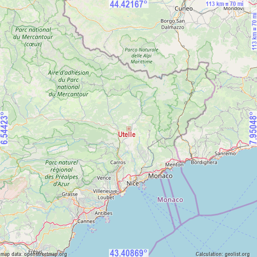
Utelle GPS coordinates[2]
43° 55' 2.424" North, 7° 14' 50.46" East
| Map corner | latitude | longitude |
|---|---|---|
| Upper-left | 44.42167°, | 6.54423° |
| Center: | 43.91734°, | 7.24735° |
| Lower-right: | 43.40869°, | 7.95048° |
| Map W x H: | 112.6×112.6 km | = 70×70mi |
| max Lat: | 51.07786° ⇑87.9% North |
| Utelle: | 43.91734° |
| min Lat: | ⇓12.1% South 41.3874° |
| min Long | Utelle | max Long |
| -5.08615° | 7.24735° | 9.52242° |
| W 96.1%⇐ | ⇒3.9% E |
Elevation
Elevation of Utelle is 610 m = 2001 ft, and this is 416.3 m = 1366 ft above average elevation for this country.
| Max E: |
2333 m = 7654 ft | 4.6% |
| Utelle | 610 m 2001 ft | |
| Avg. | 193.7 m = 635 ft | |
Min E: |
-1 m = -3 ft | 95.4% |
See also: France elevation on elevation.city.
Geographical zone
Utelle is located in North temperate zone (between Tropic of Cancer and the Arctic Circle). Distance of this Northern Tropic circle is 2277.2 km =1415 mi to South.| Distance of | km | miles | from Utelle |
|---|---|---|---|
| North Pole | 5123.9 | 3183.8 | to North |
| Arctic Circle | 2518 | 1564.6 | to North |
| Tropic Cancer | 2277.2 | 1415 | to South |
| Equator | 4883.2 | 3034.3 | to South |


Nearby cities:
15 places around Utelle: (largest is in red/bold)
• Belvédère
12.3 km =7.6 mi,  28°
28°
• Bendejun
9.8 km =6.1 mi,  157°
157°
• Berre-les-Alpes
11.7 km =7.3 mi,  145°
145°
• Bonson
7.6 km =4.7 mi,  217°
217°
• Clans
11.8 km =7.3 mi,  317°
317°
• Coaraze
7 km =4.3 mi, 147°
• Gilette
10.1 km =6.3 mi, 221°
• La Roquette-sur-Var
10.6 km =6.6 mi,  201°
201°
• Lantosque
8.2 km =5.1 mi,  39°
39°
• Levens
6.7 km =4.2 mi, 195°
• Lucéram
9.8 km =6.1 mi,  112°
112°
• Roquebillière
11.6 km =7.2 mi,  24°
24°
• Saint-Blaise
10.7 km =6.6 mi,  184°
184°
• Saint-Martin-du-Var
11.9 km =7.4 mi, 202°
• Villars-sur-Var
12.2 km =7.6 mi,  280°
280°
Sources, notices
• [Note1] Compared only with cities in France existing in our database
• [Src1] Map data: © OpenStreetMap contributors (CC-BY-SA)
• [Src2] Other city data from geonames.org with taken over terms of usage.
• [Src3] Geographical zone / Annual Mean Temperature by Robert A. Rohde @ Wikipedia
