Puget-Théniers geodata
Puget-Théniers (Provence-Alpes-Côte d'Azur) is a populated place; located in France in Europe/Paris (GMT+2) time zone. With population of 1,854 people, there are 5117 cities with bigger population in this country. Compared to other cities in France, 87.5% of cities are located further ↑North; 94.2% of cities are located further ←West and 90% of cities have lower elevation than Puget-Théniers. Note1
Administrative division(s):
- Level 1: Provence-Alpes-Côte d'Azur
- Level 2: Alpes-Maritimes
- Level 3: Arrondissement de Nice
- Level 4: Puget-Théniers


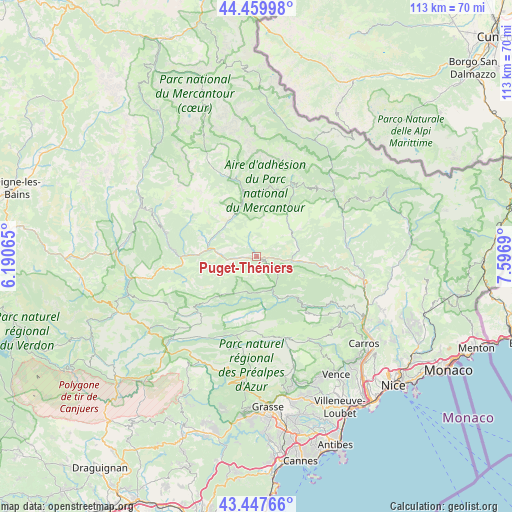
Puget-Théniers GPS coordinates[2]
43° 57' 21.528" North, 6° 53' 37.608" East
| Map corner | latitude | longitude |
|---|---|---|
| Upper-left | 44.45998°, | 6.19065° |
| Center: | 43.95598°, | 6.89378° |
| Lower-right: | 43.44766°, | 7.5969° |
| Map W x H: | 112.6×112.6 km | = 70×70mi |
| max Lat: | 51.07786° ⇑87.5% North |
| Puget-Théniers: | 43.95598° |
| min Lat: | ⇓12.5% South 41.3874° |
| min Long | Puget-Théniers | max Long |
| -5.08615° | 6.89378° | 9.52242° |
| W 94.2%⇐ | ⇒5.8% E |
Elevation
Elevation of Puget-Théniers is 427 m = 1401 ft, and this is 233.3 m = 765 ft above average elevation for this country.
| Max E: |
2333 m = 7654 ft | 10% |
| Puget-Théniers | 427 m 1401 ft | |
| Avg. | 193.7 m = 635 ft | |
Min E: |
-1 m = -3 ft | 90% |
See also: France elevation on elevation.city.
Geographical zone
Puget-Théniers is located in North temperate zone (between Tropic of Cancer and the Arctic Circle). Distance of this Northern Tropic circle is 2281.5 km =1417.7 mi to South.| Distance of | km | miles | from Puget-Théniers |
|---|---|---|---|
| North Pole | 5119.6 | 3181.2 | to North |
| Arctic Circle | 2513.7 | 1561.9 | to North |
| Tropic Cancer | 2281.5 | 1417.7 | to South |
| Equator | 4887.4 | 3036.9 | to South |


Nearby cities:
15 places around Puget-Théniers: (largest is in red/bold)
• Annot
18 km =11.2 mi,  273°
273°
• Bonson
25.9 km =16.1 mi,  113°
113°
• Clans
20.8 km =12.9 mi,  77°
77°
• Entrevaux
6.7 km =4.2 mi,  264°
264°
• Gilette
24.6 km =15.3 mi,  118°
118°
• Guillaumes
15.3 km =9.5 mi,  347°
347°
• Isola
28.5 km =17.7 mi,  26°
26°
• La Roquette-sur-Var
28.3 km =17.6 mi, 120°
• Le Broc
27.5 km =17.1 mi,  126°
126°
• Levens
28.7 km =17.8 mi, 111°
• Péone
17.9 km =11.1 mi,  3°
3°
• Roquesteron
13.1 km =8.1 mi,  139°
139°
• Saint-Martin-du-Var
28.3 km =17.6 mi, 122°
• Utelle
28.6 km =17.8 mi,  98°
98°
• Villars-sur-Var
16.4 km =10.2 mi, 97°
Sources, notices
• [Note1] Compared only with cities in France existing in our database
• [Src1] Map data: © OpenStreetMap contributors (CC-BY-SA)
• [Src2] Other city data from geonames.org with taken over terms of usage.
• [Src3] Geographical zone / Annual Mean Temperature by Robert A. Rohde @ Wikipedia
