Lantosque geodata
Lantosque (Provence-Alpes-Côte d'Azur) is a populated place; located in France in Europe/Paris (GMT+2) time zone. With population of 1,063 people, there are 8380 cities with bigger population in this country. Compared to other cities in France, 87.3% of cities are located further ↑North; 96.6% of cities are located further ←West and 92% of cities have lower elevation than Lantosque. Note1
Administrative division(s):
- Level 1: Provence-Alpes-Côte d'Azur
- Level 2: Alpes-Maritimes
- Level 3: Arrondissement de Nice
- Level 4: Lantosque


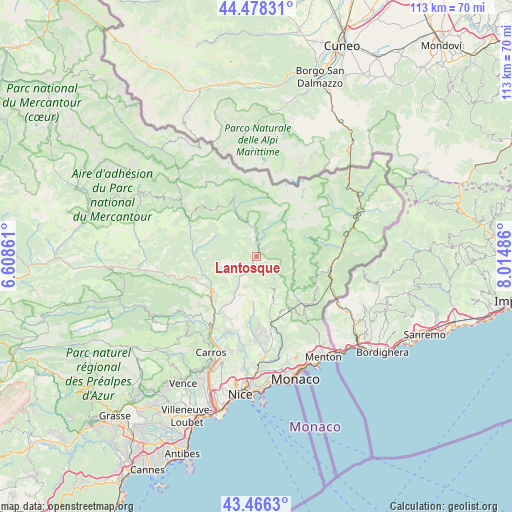
Lantosque GPS coordinates[2]
43° 58' 28.056" North, 7° 18' 42.264" East
| Map corner | latitude | longitude |
|---|---|---|
| Upper-left | 44.47831°, | 6.60861° |
| Center: | 43.97446°, | 7.31174° |
| Lower-right: | 43.4663°, | 8.01486° |
| Map W x H: | 112.5×112.5 km | = 69.9×69.9mi |
| max Lat: | 51.07786° ⇑87.3% North |
| Lantosque: | 43.97446° |
| min Lat: | ⇓12.7% South 41.3874° |
| min Long | Lantosque | max Long |
| -5.08615° | 7.31174° | 9.52242° |
| W 96.6%⇐ | ⇒3.4% E |
Elevation
Elevation of Lantosque is 477 m = 1565 ft, and this is 283.3 m = 929 ft above average elevation for this country.
| Max E: |
2333 m = 7654 ft | 8% |
| Lantosque | 477 m 1565 ft | |
| Avg. | 193.7 m = 635 ft | |
Min E: |
-1 m = -3 ft | 92% |
See also: France elevation on elevation.city.
Geographical zone
Lantosque is located in North temperate zone (between Tropic of Cancer and the Arctic Circle). Distance of this Northern Tropic circle is 2283.6 km =1419 mi to South.| Distance of | km | miles | from Lantosque |
|---|---|---|---|
| North Pole | 5117.6 | 3179.9 | to North |
| Arctic Circle | 2511.7 | 1560.7 | to North |
| Tropic Cancer | 2283.6 | 1419 | to South |
| Equator | 4889.5 | 3038.2 | to South |


Nearby cities:
15 places around Lantosque: (largest is in red/bold)
• Belvédère
4.6 km =2.9 mi,  9°
9°
• Bendejun
15.4 km =9.6 mi,  185°
185°
• Berre-les-Alpes
16.1 km =10 mi,  175°
175°
• Bonson
15.8 km =9.8 mi,  218°
218°
• Breil-sur-Roya
16.8 km =10.4 mi,  104°
104°
• Clans
13.3 km =8.3 mi,  280°
280°
• Coaraze
12.3 km =7.6 mi, 186°
• Levens
14.5 km =9 mi,  208°
208°
• Lucéram
10.9 km =6.8 mi,  159°
159°
• L’Escarène
15.9 km =9.9 mi,  167°
167°
• Roquebillière
4.2 km =2.6 mi,  355°
355°
• Saint-Martin-Vésubie
11.4 km =7.1 mi,  336°
336°
• Sospel
15.3 km =9.5 mi,  134°
134°
• Utelle
8.2 km =5.1 mi, 219°
• Villars-sur-Var
17.7 km =11 mi,  256°
256°
Sources, notices
• [Note1] Compared only with cities in France existing in our database
• [Src1] Map data: © OpenStreetMap contributors (CC-BY-SA)
• [Src2] Other city data from geonames.org with taken over terms of usage.
• [Src3] Geographical zone / Annual Mean Temperature by Robert A. Rohde @ Wikipedia
