Levens geodata
Levens (Provence-Alpes-Côte d'Azur) is a populated place; located in France in Europe/Paris (GMT+2) time zone. With population of 3,835 people, there are 2563 cities with bigger population in this country. Compared to other cities in France, 88.5% of cities are located further ↑North; 95.9% of cities are located further ←West and 96.4% of cities have lower elevation than Levens. Note1
Administrative division(s):
- Level 1: Provence-Alpes-Côte d'Azur
- Level 2: Alpes-Maritimes
- Level 3: Arrondissement de Nice
- Level 4: Levens


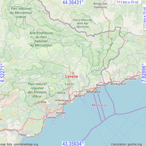
Levens GPS coordinates[2]
43° 51' 34.128" North, 7° 13' 32.988" East
| Map corner | latitude | longitude |
|---|---|---|
| Upper-left | 44.36431°, | 6.52271° |
| Center: | 43.85948°, | 7.22583° |
| Lower-right: | 43.35034°, | 7.92896° |
| Map W x H: | 112.7×112.7 km | = 70×70mi |
| max Lat: | 51.07786° ⇑88.5% North |
| Levens: | 43.85948° |
| min Lat: | ⇓11.5% South 41.3874° |
| min Long | Levens | max Long |
| -5.08615° | 7.22583° | 9.52242° |
| W 95.9%⇐ | ⇒4.1% E |
Elevation
Elevation of Levens is 677 m = 2221 ft, and this is 483.3 m = 1586 ft above average elevation for this country.
| Max E: |
2333 m = 7654 ft | 3.6% |
| Levens | 677 m 2221 ft | |
| Avg. | 193.7 m = 635 ft | |
Min E: |
-1 m = -3 ft | 96.4% |
See also: France elevation on elevation.city.
Geographical zone
Levens is located in North temperate zone (between Tropic of Cancer and the Arctic Circle). Distance of this Northern Tropic circle is 2270.8 km =1411 mi to South.| Distance of | km | miles | from Levens |
|---|---|---|---|
| North Pole | 5130.3 | 3187.8 | to North |
| Arctic Circle | 2524.5 | 1568.7 | to North |
| Tropic Cancer | 2270.8 | 1411 | to South |
| Equator | 4876.7 | 3030.2 | to South |


Nearby cities:
15 places around Levens: (largest is in red/bold)
• Aspremont
8.6 km =5.3 mi,  170°
170°
• Bendejun
6.1 km =3.8 mi,  115°
115°
• Berre-les-Alpes
8.9 km =5.5 mi,  111°
111°
• Bonson
2.9 km =1.8 mi,  277°
277°
• Carros
8.1 km =5 mi,  202°
202°
• Castagniers
7.6 km =4.7 mi,  176°
176°
• Coaraze
5.5 km =3.4 mi,  84°
84°
• Contes
8.8 km =5.5 mi,  126°
126°
• Gilette
5.1 km =3.2 mi,  257°
257°
• La Roquette-sur-Var
4.1 km =2.5 mi,  211°
211°
• Le Broc
7.3 km =4.5 mi,  219°
219°
• Saint-Blaise
4.3 km =2.7 mi, 167°
• Saint-Martin-du-Var
5.4 km =3.4 mi, 211°
• Tourrette-Levens
9.1 km =5.7 mi,  153°
153°
• Utelle
6.7 km =4.2 mi,  15°
15°
Sources, notices
• [Note1] Compared only with cities in France existing in our database
• [Src1] Map data: © OpenStreetMap contributors (CC-BY-SA)
• [Src2] Other city data from geonames.org with taken over terms of usage.
• [Src3] Geographical zone / Annual Mean Temperature by Robert A. Rohde @ Wikipedia
