Villandry geodata
Villandry (Centre) is a populated place; located in France in Europe/Paris (GMT+2) time zone. With population of 1,118 people, there are 8025 cities with bigger population in this country. Compared to other cities in France, 50.9% of cities are located further ↑North; 73.3% of cities are located further →East and 83.1% of cities have higher elevation than Villandry. Note1
Administrative division(s):
- Level 1: Centre
- Level 2: Département d'Indre-et-Loire
- Level 3: Arrondissement de Tours
- Level 4: Villandry


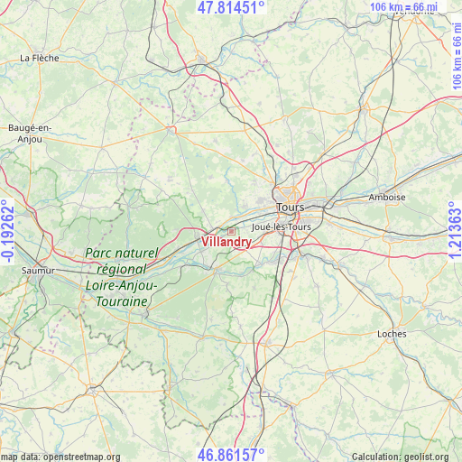
Villandry GPS coordinates[2]
47° 20' 24.684" North, 0° 30' 37.8" East
| Map corner | latitude | longitude |
|---|---|---|
| Upper-left | 47.81451°, | -0.19262° |
| Center: | 47.34019°, | 0.5105° |
| Lower-right: | 46.86157°, | 1.21363° |
| Map W x H: | 106×106 km | = 65.9×65.9mi |
| max Lat: | 51.07786° ⇑50.9% North |
| Villandry: | 47.34019° |
| min Lat: | ⇓49.1% South 41.3874° |
| min Long | Villandry | max Long |
| -5.08615° | 0.5105° | 9.52242° |
| W 26.7%⇐ | ⇒73.3% E |
Elevation
Elevation of Villandry is 47 m = 154 ft, and this is 146.7 m = 481 ft below average elevation for this country.
| Max E: |
2333 m = 7654 ft | 83.1% |
| Avg. | 193.7 m = 635 ft | |
| Villandry | 47 m = 154 ft | |
Min E: |
-1 m = -3 ft | 16.9% |
See also: France elevation on elevation.city.
Geographical zone
Villandry is located in North temperate zone (between Tropic of Cancer and the Arctic Circle). Distance of this North polar circle is 2137.4 km =1328.1 mi to North.| Distance of | km | miles | from Villandry |
|---|---|---|---|
| North Pole | 4743.3 | 2947.3 | to North |
| Arctic Circle | 2137.4 | 1328.1 | to North |
| Tropic Cancer | 2657.8 | 1651.5 | to South |
| Equator | 5263.7 | 3270.7 | to South |


Nearby cities:
15 places around Villandry: (largest is in red/bold)
• Azay-le-Rideau
9 km =5.6 mi,  199°
199°
• Ballan-Miré
7.8 km =4.8 mi,  89°
89°
• Berthenay
2.8 km =1.7 mi,  23°
23°
• Cinq-Mars-la-Pile
4 km =2.5 mi,  280°
280°
• Druye
4 km =2.5 mi,  148°
148°
• Fondettes
9.6 km =6 mi,  42°
42°
• La Chapelle-aux-Naux
6.8 km =4.2 mi,  248°
248°
• Langeais
8.4 km =5.2 mi,  259°
259°
• Lignières-de-Touraine
8.5 km =5.3 mi,  236°
236°
• Luynes
5.9 km =3.7 mi,  34°
34°
• Mazières-de-Touraine
8 km =5 mi,  306°
306°
• Saint-Genouph
7.8 km =4.8 mi,  57°
57°
• Saint-Étienne-de-Chigny
5.1 km =3.2 mi, 19°
• Savonnières
3.1 km =1.9 mi,  74°
74°
• Vallères
4.2 km =2.6 mi,  220°
220°
Sources, notices
• [Note1] Compared only with cities in France existing in our database
• [Src1] Map data: © OpenStreetMap contributors (CC-BY-SA)
• [Src2] Other city data from geonames.org with taken over terms of usage.
• [Src3] Geographical zone / Annual Mean Temperature by Robert A. Rohde @ Wikipedia
