Langeais geodata
Langeais (Centre) is a populated place; located in France in Europe/Paris (GMT+2) time zone. With population of 4,034 people, there are 2433 cities with bigger population in this country. Compared to other cities in France, 51.1% of cities are located further ↑North; 74.3% of cities are located further →East and 84.1% of cities have higher elevation than Langeais. Note1
Administrative division(s):
- Level 1: Centre
- Level 2: Département d'Indre-et-Loire
- Level 3: Arrondissement de Chinon
- Level 4: Langeais


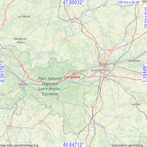
Langeais GPS coordinates[2]
47° 19' 33.132" North, 0° 24' 4.896" East
| Map corner | latitude | longitude |
|---|---|---|
| Upper-left | 47.80032°, | -0.30176° |
| Center: | 47.32587°, | 0.40136° |
| Lower-right: | 46.84712°, | 1.10449° |
| Map W x H: | 106×106 km | = 65.9×65.9mi |
| max Lat: | 51.07786° ⇑51.1% North |
| Langeais: | 47.32587° |
| min Lat: | ⇓48.9% South 41.3874° |
| min Long | Langeais | max Long |
| -5.08615° | 0.40136° | 9.52242° |
| W 25.7%⇐ | ⇒74.3% E |
Elevation
Elevation of Langeais is 44 m = 144 ft, and this is 149.7 m = 491 ft below average elevation for this country.
| Max E: |
2333 m = 7654 ft | 84.1% |
| Avg. | 193.7 m = 635 ft | |
| Langeais | 44 m = 144 ft | |
Min E: |
-1 m = -3 ft | 15.9% |
See also: France elevation on elevation.city.
Geographical zone
Langeais is located in North temperate zone (between Tropic of Cancer and the Arctic Circle). Distance of this North polar circle is 2139 km =1329.1 mi to North.| Distance of | km | miles | from Langeais |
|---|---|---|---|
| North Pole | 4744.9 | 2948.3 | to North |
| Arctic Circle | 2139 | 1329.1 | to North |
| Tropic Cancer | 2656.2 | 1650.5 | to South |
| Equator | 5262.1 | 3269.7 | to South |


Nearby cities:
15 places around Langeais: (largest is in red/bold)
• Azay-le-Rideau
8.7 km =5.4 mi,  142°
142°
• Berthenay
10.2 km =6.3 mi,  65°
65°
• Bréhémont
4.7 km =2.9 mi,  222°
222°
• Cheillé
7.2 km =4.5 mi,  177°
177°
• Cinq-Mars-la-Pile
4.9 km =3 mi,  62°
62°
• Cléré-les-Pins
11.1 km =6.9 mi,  355°
355°
• Druye
10.5 km =6.5 mi,  100°
100°
• La Chapelle-aux-Naux
2.1 km =1.3 mi,  115°
115°
• Lignières-de-Touraine
3.4 km =2.1 mi,  159°
159°
• Mazières-de-Touraine
6.6 km =4.1 mi,  15°
15°
• Rivarennes
7.5 km =4.7 mi,  208°
208°
• Saint-Michel-sur-Loire
4.5 km =2.8 mi,  243°
243°
• Saint-Patrice
9.3 km =5.8 mi, 240°
• Vallères
5.7 km =3.5 mi,  106°
106°
• Villandry
8.4 km =5.2 mi,  79°
79°
Sources, notices
• [Note1] Compared only with cities in France existing in our database
• [Src1] Map data: © OpenStreetMap contributors (CC-BY-SA)
• [Src2] Other city data from geonames.org with taken over terms of usage.
• [Src3] Geographical zone / Annual Mean Temperature by Robert A. Rohde @ Wikipedia
