Le Thoronet geodata
Le Thoronet (Provence-Alpes-Côte d'Azur) is a populated place; located in France in Europe/Paris (GMT+2) time zone. With population of 1,649 people, there are 5669 cities with bigger population in this country. Compared to other cities in France, 93.7% of cities are located further ↑North; 90.2% of cities are located further ←West and 50.1% of cities have lower elevation than Le Thoronet. Note1
Administrative division(s):
- Level 1: Provence-Alpes-Côte d'Azur
- Level 2: Var
- Level 3: Arrondissement de Brignoles
- Level 4: Le Thoronet


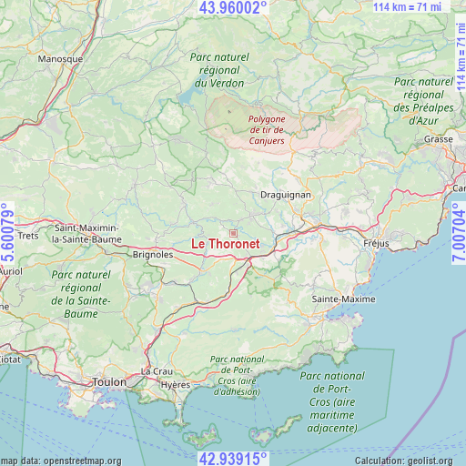
Le Thoronet GPS coordinates[2]
43° 27' 6.264" North, 6° 18' 14.076" East
| Map corner | latitude | longitude |
|---|---|---|
| Upper-left | 43.96002°, | 5.60079° |
| Center: | 43.45174°, | 6.30391° |
| Lower-right: | 42.93915°, | 7.00704° |
| Map W x H: | 113.5×113.5 km | = 70.5×70.5mi |
| max Lat: | 51.07786° ⇑93.7% North |
| Le Thoronet: | 43.45174° |
| min Lat: | ⇓6.3% South 41.3874° |
| min Long | Le Thoronet | max Long |
| -5.08615° | 6.30391° | 9.52242° |
| W 90.2%⇐ | ⇒9.8% E |
Elevation
Elevation of Le Thoronet is 132 m = 433 ft, and this is 61.7 m = 202 ft below average elevation for this country.
| Max E: |
2333 m = 7654 ft | 49.9% |
| Avg. | 193.7 m = 635 ft | |
| Le Thoronet | 132 m = 433 ft | |
Min E: |
-1 m = -3 ft | 50.1% |
See also: France elevation on elevation.city.
Geographical zone
Le Thoronet is located in North temperate zone (between Tropic of Cancer and the Arctic Circle). Distance of this Northern Tropic circle is 2225.5 km =1382.9 mi to South.| Distance of | km | miles | from Le Thoronet |
|---|---|---|---|
| North Pole | 5175.7 | 3216 | to North |
| Arctic Circle | 2569.8 | 1596.8 | to North |
| Tropic Cancer | 2225.5 | 1382.9 | to South |
| Equator | 4831.4 | 3002.1 | to South |


Nearby cities:
15 places around Le Thoronet: (largest is in red/bold)
• Cabasse
7.4 km =4.6 mi,  247°
247°
• Carcès
10.2 km =6.3 mi,  285°
285°
• Entrecasteaux
8.7 km =5.4 mi,  325°
325°
• Flassans-sur-Issole
11.4 km =7.1 mi,  215°
215°
• Flayosc
11.8 km =7.3 mi,  39°
39°
• Gonfaron
14.7 km =9.1 mi,  184°
184°
• Le Cannet-des-Maures
7.2 km =4.5 mi,  156°
156°
• Le Luc
6.4 km =4 mi,  173°
173°
• Les Arcs
14.2 km =8.8 mi,  84°
84°
• Lorgues
6.5 km =4 mi,  45°
45°
• Salernes
13.7 km =8.5 mi,  335°
335°
• Taradeau
10 km =6.2 mi,  88°
88°
• Vidauban
10.7 km =6.6 mi,  104°
104°
• Villecroze
14.7 km =9.1 mi,  351°
351°
• Vins-sur-Caramy
13.2 km =8.2 mi,  261°
261°
Sources, notices
• [Note1] Compared only with cities in France existing in our database
• [Src1] Map data: © OpenStreetMap contributors (CC-BY-SA)
• [Src2] Other city data from geonames.org with taken over terms of usage.
• [Src3] Geographical zone / Annual Mean Temperature by Robert A. Rohde @ Wikipedia
