La Garde-Freinet geodata
La Garde-Freinet (Provence-Alpes-Côte d'Azur) is a populated place; located in France in Europe/Paris (GMT+2) time zone. With population of 1,777 people, there are 5340 cities with bigger population in this country. Compared to other cities in France, 95.3% of cities are located further ↑North; 91.5% of cities are located further ←West and 85.4% of cities have lower elevation than La Garde-Freinet. Note1
Administrative division(s):
- Level 1: Provence-Alpes-Côte d'Azur
- Level 2: Var
- Level 3: Arrondissement de Draguignan
- Level 4: La Garde-Freinet


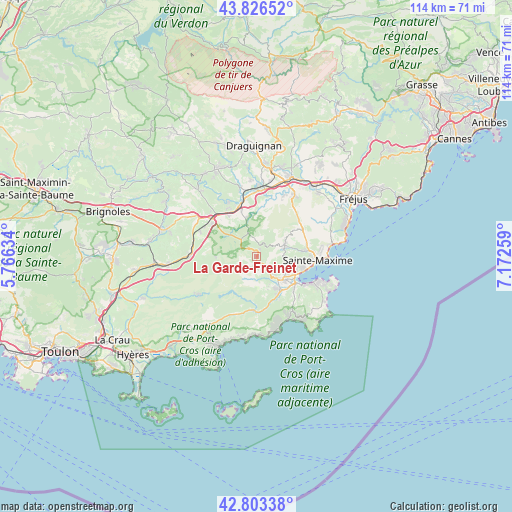
La Garde-Freinet GPS coordinates[2]
43° 19' 1.56" North, 6° 28' 10.056" East
| Map corner | latitude | longitude |
|---|---|---|
| Upper-left | 43.82652°, | 5.76634° |
| Center: | 43.3171°, | 6.46946° |
| Lower-right: | 42.80338°, | 7.17259° |
| Map W x H: | 113.8×113.8 km | = 70.7×70.7mi |
| max Lat: | 51.07786° ⇑95.3% North |
| La Garde-Freinet: | 43.3171° |
| min Lat: | ⇓4.7% South 41.3874° |
| min Long | La Garde-Freine | max Long |
| -5.08615° | 6.46946° | 9.52242° |
| W 91.5%⇐ | ⇒8.5% E |
Elevation
Elevation of La Garde-Freinet is 351 m = 1152 ft, and this is 157.3 m = 516 ft above average elevation for this country.
| Max E: |
2333 m = 7654 ft | 14.6% |
| La Garde-Freinet | 351 m 1152 ft | |
| Avg. | 193.7 m = 635 ft | |
Min E: |
-1 m = -3 ft | 85.4% |
See also: France elevation on elevation.city.
Geographical zone
La Garde-Freinet is located in North temperate zone (between Tropic of Cancer and the Arctic Circle). Distance of this Northern Tropic circle is 2210.5 km =1373.5 mi to South.| Distance of | km | miles | from La Garde-Freinet |
|---|---|---|---|
| North Pole | 5190.7 | 3225.4 | to North |
| Arctic Circle | 2584.8 | 1606.1 | to North |
| Tropic Cancer | 2210.5 | 1373.5 | to South |
| Equator | 4816.4 | 2992.8 | to South |


Nearby cities:
15 places around La Garde-Freinet: (largest is in red/bold)
• Cogolin
8.6 km =5.3 mi,  145°
145°
• Collobrières
15.7 km =9.8 mi,  235°
235°
• Gassin
13.6 km =8.5 mi,  136°
136°
• Gonfaron
14.6 km =9.1 mi,  271°
271°
• Grimaud
6.5 km =4 mi, 139°
• La Croix-Valmer
14.6 km =9.1 mi, 146°
• La Môle
12.2 km =7.6 mi,  180°
180°
• Le Cannet-des-Maures
13.4 km =8.3 mi,  308°
308°
• Le Luc
15.3 km =9.5 mi,  304°
304°
• Le Plan-de-la-Tour
6.8 km =4.2 mi,  74°
74°
• Les Mayons
9 km =5.6 mi, 267°
• Saint-Tropez
14.9 km =9.3 mi,  111°
111°
• Sainte-Maxime
13.7 km =8.5 mi,  93°
93°
• Taradeau
15.6 km =9.7 mi,  347°
347°
• Vidauban
12.6 km =7.8 mi, 346°
Sources, notices
• [Note1] Compared only with cities in France existing in our database
• [Src1] Map data: © OpenStreetMap contributors (CC-BY-SA)
• [Src2] Other city data from geonames.org with taken over terms of usage.
• [Src3] Geographical zone / Annual Mean Temperature by Robert A. Rohde @ Wikipedia
