Vicq geodata
Vicq (Hauts-de-France) is a populated place; located in France in Europe/Paris (GMT+2) time zone. With population of 1,207 people, there are 7490 cities with bigger population in this country. Compared to other cities in France, 96.5% of cities are located further ↓South; 65.1% of cities are located further ←West and 93.9% of cities have higher elevation than Vicq. Note1
Administrative division(s):
- Level 1: Hauts-de-France
- Level 2: Nord
- Level 3: Arrondissement de Valenciennes
- Level 4: Vicq


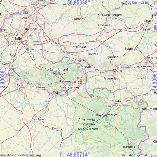
Vicq GPS coordinates[2]
50° 24' 26.568" North, 3° 36' 12.528" East
| Map corner | latitude | longitude |
|---|---|---|
| Upper-left | 50.85338°, | 2.90036° |
| Center: | 50.40738°, | 3.60348° |
| Lower-right: | 49.95714°, | 4.30661° |
| Map W x H: | 99.7×99.7 km | = 62×62mi |
| max Lat: | 51.07786° ⇑3.5% North |
| Vicq: | 50.40738° |
| min Lat: | ⇓96.5% South 41.3874° |
| min Long | Vicq | max Long |
| -5.08615° | 3.60348° | 9.52242° |
| W 65.1%⇐ | ⇒34.9% E |
Elevation
Elevation of Vicq is 20 m = 66 ft, and this is 173.7 m = 570 ft below average elevation for this country.
| Max E: |
2333 m = 7654 ft | 93.9% |
| Avg. | 193.7 m = 635 ft | |
| Vicq | 20 m = 66 ft | |
Min E: |
-1 m = -3 ft | 6.1% |
See also: France elevation on elevation.city.
Geographical zone
Vicq is located in North temperate zone (between Tropic of Cancer and the Arctic Circle). Distance of this North polar circle is 1796.4 km =1116.2 mi to North.| Distance of | km | miles | from Vicq |
|---|---|---|---|
| North Pole | 4402.3 | 2735.5 | to North |
| Arctic Circle | 1796.4 | 1116.2 | to North |
| Tropic Cancer | 2998.9 | 1863.4 | to South |
| Equator | 5604.8 | 3482.7 | to South |


Nearby cities:
15 places around Vicq: (largest is in red/bold)
• Bruay-sur-l’Escaut
4.3 km =2.7 mi,  257°
257°
• Condé-sur-l’Escaut
5.3 km =3.3 mi,  348°
348°
• Crespin
4.4 km =2.7 mi,  69°
69°
• Escautpont
3.8 km =2.4 mi,  289°
289°
• Estreux
6.3 km =3.9 mi,  185°
185°
• Fresnes-sur-Escaut
3.5 km =2.2 mi,  327°
327°
• Odomez
7.6 km =4.7 mi,  311°
311°
• Onnaing
2.4 km =1.5 mi, 186°
• Quarouble
2.7 km =1.7 mi,  149°
149°
• Quiévrechain
4.9 km =3 mi,  110°
110°
• Rombies-et-Marchipont
5.5 km =3.4 mi, 150°
• Saint-Saulve
5.2 km =3.2 mi,  220°
220°
• Thivencelle
4.2 km =2.6 mi,  30°
30°
• Valenciennes
7.7 km =4.8 mi,  225°
225°
• Vieux-Condé
6.3 km =3.9 mi,  336°
336°
Sources, notices
• [Note1] Compared only with cities in France existing in our database
• [Src1] Map data: © OpenStreetMap contributors (CC-BY-SA)
• [Src2] Other city data from geonames.org with taken over terms of usage.
• [Src3] Geographical zone / Annual Mean Temperature by Robert A. Rohde @ Wikipedia
