Escautpont geodata
Escautpont (Hauts-de-France) is a populated place; located in France in Europe/Paris (GMT+2) time zone. With population of 4,324 people, there are 2280 cities with bigger population in this country. Compared to other cities in France, 96.6% of cities are located further ↓South; 64.7% of cities are located further ←West and 92.4% of cities have higher elevation than Escautpont. Note1
Administrative division(s):
- Level 1: Hauts-de-France
- Level 2: Nord
- Level 3: Arrondissement de Valenciennes
- Level 4: Escautpont


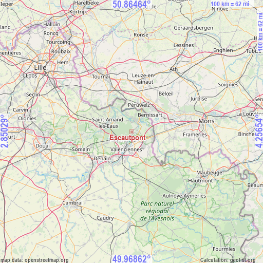
Escautpont GPS coordinates[2]
50° 25' 7.5" North, 3° 33' 12.276" East
| Map corner | latitude | longitude |
|---|---|---|
| Upper-left | 50.86464°, | 2.85029° |
| Center: | 50.41875°, | 3.55341° |
| Lower-right: | 49.96862°, | 4.25654° |
| Map W x H: | 99.6×99.6 km | = 61.9×61.9mi |
| max Lat: | 51.07786° ⇑3.4% North |
| Escautpont: | 50.41875° |
| min Lat: | ⇓96.6% South 41.3874° |
| min Long | Escautpont | max Long |
| -5.08615° | 3.55341° | 9.52242° |
| W 64.7%⇐ | ⇒35.3% E |
Elevation
Elevation of Escautpont is 24 m = 79 ft, and this is 169.7 m = 557 ft below average elevation for this country.
| Max E: |
2333 m = 7654 ft | 92.4% |
| Avg. | 193.7 m = 635 ft | |
| Escautpont | 24 m = 79 ft | |
Min E: |
-1 m = -3 ft | 7.6% |
See also: France elevation on elevation.city.
Geographical zone
Escautpont is located in North temperate zone (between Tropic of Cancer and the Arctic Circle). Distance of this North polar circle is 1795.1 km =1115.4 mi to North.| Distance of | km | miles | from Escautpont |
|---|---|---|---|
| North Pole | 4401 | 2734.7 | to North |
| Arctic Circle | 1795.1 | 1115.4 | to North |
| Tropic Cancer | 3000.1 | 1864.2 | to South |
| Equator | 5606 | 3483.4 | to South |


Nearby cities:
15 places around Escautpont: (largest is in red/bold)
• Anzin
6.3 km =3.9 mi,  214°
214°
• Beuvrages
5.7 km =3.5 mi,  227°
227°
• Bruay-sur-l’Escaut
2.3 km =1.4 mi,  197°
197°
• Bruille-Saint-Amand
6.5 km =4 mi,  324°
324°
• Condé-sur-l’Escaut
4.7 km =2.9 mi,  32°
32°
• Fresnes-sur-Escaut
2.4 km =1.5 mi,  45°
45°
• Hergnies
6.3 km =3.9 mi,  342°
342°
• Odomez
4.4 km =2.7 mi,  331°
331°
• Onnaing
4.9 km =3 mi,  138°
138°
• Quarouble
6.1 km =3.8 mi,  126°
126°
• Raismes
6.3 km =3.9 mi, 231°
• Saint-Saulve
5.3 km =3.3 mi,  177°
177°
• Thivencelle
6.2 km =3.9 mi,  67°
67°
• Vicq
3.8 km =2.4 mi,  109°
109°
• Vieux-Condé
4.6 km =2.9 mi,  12°
12°
Sources, notices
• [Note1] Compared only with cities in France existing in our database
• [Src1] Map data: © OpenStreetMap contributors (CC-BY-SA)
• [Src2] Other city data from geonames.org with taken over terms of usage.
• [Src3] Geographical zone / Annual Mean Temperature by Robert A. Rohde @ Wikipedia
