Augé geodata
Augé (Nouvelle-Aquitaine) is a populated place; located in France in Europe/Paris (GMT+2) time zone. With population of 817 people, there are 10416 cities with bigger population in this country. Compared to other cities in France, 60.6% of cities are located further ↑North; 80.7% of cities are located further →East and 72.3% of cities have higher elevation than Augé. Note1
Administrative division(s):
- Level 1: Nouvelle-Aquitaine
- Level 2: Département des Deux-Sèvres
- Level 3: Arrondissement de Niort
- Level 4: Augé


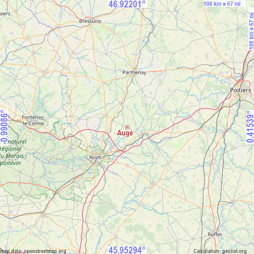
Augé GPS coordinates[2]
46° 26' 22.668" North, 0° 17' 15.828" West
| Map corner | latitude | longitude |
|---|---|---|
| Upper-left | 46.92201°, | -0.99086° |
| Center: | 46.43963°, | -0.28773° |
| Lower-right: | 45.95294°, | 0.41539° |
| Map W x H: | 107.8×107.7 km | = 67×66.9mi |
| max Lat: | 51.07786° ⇑60.6% North |
| Augé: | 46.43963° |
| min Lat: | ⇓39.4% South 41.3874° |
| min Long | Augé | max Long |
| -5.08615° | -0.28773° | 9.52242° |
| W 19.3%⇐ | ⇒80.7% E |
Elevation
Elevation of Augé is 73 m = 240 ft, and this is 120.7 m = 396 ft below average elevation for this country.
| Max E: |
2333 m = 7654 ft | 72.3% |
| Avg. | 193.7 m = 635 ft | |
| Augé | 73 m = 240 ft | |
Min E: |
-1 m = -3 ft | 27.7% |
See also: France elevation on elevation.city.
Geographical zone
Augé is located in North temperate zone (between Tropic of Cancer and the Arctic Circle). Distance of this North polar circle is 2237.6 km =1390.4 mi to North.| Distance of | km | miles | from Augé |
|---|---|---|---|
| North Pole | 4843.5 | 3009.6 | to North |
| Arctic Circle | 2237.6 | 1390.4 | to North |
| Tropic Cancer | 2557.7 | 1589.3 | to South |
| Equator | 5163.6 | 3208.5 | to South |


Nearby cities:
15 places around Augé: (largest is in red/bold)
• Azay-le-Brûlé
5.3 km =3.3 mi,  143°
143°
• Champdeniers-Saint-Denis
9.9 km =6.2 mi,  299°
299°
• Cherveux
6 km =3.7 mi,  243°
243°
• Exireuil
7.4 km =4.6 mi,  95°
95°
• François
8.8 km =5.5 mi,  210°
210°
• Germond-Rouvre
9.9 km =6.2 mi,  276°
276°
• La Crèche
8.2 km =5.1 mi,  186°
186°
• Nanteuil
9.2 km =5.7 mi,  109°
109°
• Romans
10.1 km =6.3 mi,  152°
152°
• Saint-Gelais
10.1 km =6.3 mi,  231°
231°
• Saint-Georges-de-Noisné
6.4 km =4 mi,  21°
21°
• Saint-Martin-de-Saint-Maixent
8.8 km =5.5 mi,  124°
124°
• Sainte-Néomaye
7.7 km =4.8 mi,  163°
163°
• Saivres
4 km =2.5 mi, 101°
• Verruyes
8.6 km =5.3 mi,  359°
359°
Sources, notices
• [Note1] Compared only with cities in France existing in our database
• [Src1] Map data: © OpenStreetMap contributors (CC-BY-SA)
• [Src2] Other city data from geonames.org with taken over terms of usage.
• [Src3] Geographical zone / Annual Mean Temperature by Robert A. Rohde @ Wikipedia
