Verrières geodata
Verrières (Nouvelle-Aquitaine) is a populated place; located in France in Europe/Paris (GMT+2) time zone. With population of 845 people, there are 10134 cities with bigger population in this country. Compared to other cities in France, 60.9% of cities are located further ↑North; 72.5% of cities are located further →East and 55.2% of cities have higher elevation than Verrières. Note1
Administrative division(s):
- Level 1: Nouvelle-Aquitaine
- Level 2: Vienne
- Level 3: Arrondissement de Montmorillon
- Level 4: Verrières


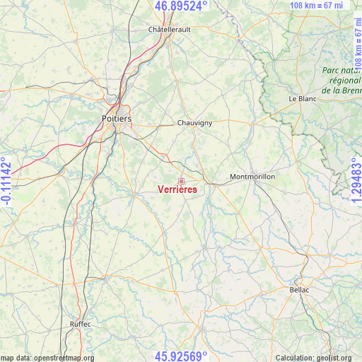
Verrières GPS coordinates[2]
46° 24' 45.432" North, 0° 35' 30.12" East
| Map corner | latitude | longitude |
|---|---|---|
| Upper-left | 46.89524°, | -0.11142° |
| Center: | 46.41262°, | 0.5917° |
| Lower-right: | 45.92569°, | 1.29483° |
| Map W x H: | 107.8×107.8 km | = 67×67mi |
| max Lat: | 51.07786° ⇑60.9% North |
| Verrières: | 46.41262° |
| min Lat: | ⇓39.1% South 41.3874° |
| min Long | Verrières | max Long |
| -5.08615° | 0.5917° | 9.52242° |
| W 27.5%⇐ | ⇒72.5% E |
Elevation
Elevation of Verrières is 116 m = 381 ft, and this is 77.7 m = 255 ft below average elevation for this country.
| Max E: |
2333 m = 7654 ft | 55.2% |
| Avg. | 193.7 m = 635 ft | |
| Verrières | 116 m = 381 ft | |
Min E: |
-1 m = -3 ft | 44.8% |
See also: France elevation on elevation.city.
Geographical zone
Verrières is located in North temperate zone (between Tropic of Cancer and the Arctic Circle). Distance of this North polar circle is 2240.6 km =1392.2 mi to North.| Distance of | km | miles | from Verrières |
|---|---|---|---|
| North Pole | 4846.5 | 3011.5 | to North |
| Arctic Circle | 2240.6 | 1392.2 | to North |
| Tropic Cancer | 2554.7 | 1587.4 | to South |
| Equator | 5160.6 | 3206.6 | to South |


Nearby cities:
15 places around Verrières: (largest is in red/bold)
• Bouresse
5.6 km =3.5 mi,  167°
167°
• Civaux
6.7 km =4.2 mi,  58°
58°
• Fleuré
9 km =5.6 mi,  323°
323°
• Gouex
9.1 km =5.7 mi,  124°
124°
• Lhommaizé
2.6 km =1.6 mi,  10°
10°
• Lussac-les-Châteaux
10.1 km =6.3 mi,  95°
95°
• Mazerolles
7.1 km =4.4 mi, 96°
• Persac
11.6 km =7.2 mi,  130°
130°
• Pouillé
13.9 km =8.6 mi,  355°
355°
• Queaux
11.1 km =6.9 mi,  148°
148°
• Saint-Maurice-la-Clouère
14.3 km =8.9 mi,  255°
255°
• Saint-Secondin
12.1 km =7.5 mi,  219°
219°
• Sillars
13.6 km =8.5 mi,  86°
86°
• Tercé
11.8 km =7.3 mi,  349°
349°
• Vernon
9.4 km =5.8 mi,  289°
289°
Sources, notices
• [Note1] Compared only with cities in France existing in our database
• [Src1] Map data: © OpenStreetMap contributors (CC-BY-SA)
• [Src2] Other city data from geonames.org with taken over terms of usage.
• [Src3] Geographical zone / Annual Mean Temperature by Robert A. Rohde @ Wikipedia
