Mazerolles geodata
Mazerolles (Nouvelle-Aquitaine) is a populated place; located in France in Europe/Paris (GMT+2) time zone. With population of 810 people, there are 10481 cities with bigger population in this country. Compared to other cities in France, 61% of cities are located further ↑North; 71.6% of cities are located further →East and 67.4% of cities have higher elevation than Mazerolles. Note1
Administrative division(s):
- Level 1: Nouvelle-Aquitaine
- Level 2: Vienne
- Level 3: Arrondissement de Montmorillon
- Level 4: Mazerolles


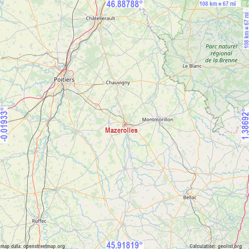
Mazerolles GPS coordinates[2]
46° 24' 18.684" North, 0° 41' 1.68" East
| Map corner | latitude | longitude |
|---|---|---|
| Upper-left | 46.88788°, | -0.01933° |
| Center: | 46.40519°, | 0.6838° |
| Lower-right: | 45.91819°, | 1.38692° |
| Map W x H: | 107.8×107.8 km | = 67×67mi |
| max Lat: | 51.07786° ⇑61% North |
| Mazerolles: | 46.40519° |
| min Lat: | ⇓39% South 41.3874° |
| min Long | Mazerolles | max Long |
| -5.08615° | 0.6838° | 9.52242° |
| W 28.4%⇐ | ⇒71.6% E |
Elevation
Elevation of Mazerolles is 84 m = 276 ft, and this is 109.7 m = 360 ft below average elevation for this country.
| Max E: |
2333 m = 7654 ft | 67.4% |
| Avg. | 193.7 m = 635 ft | |
| Mazerolles | 84 m = 276 ft | |
Min E: |
-1 m = -3 ft | 32.6% |
See also: France elevation on elevation.city.
Geographical zone
Mazerolles is located in North temperate zone (between Tropic of Cancer and the Arctic Circle). Distance of this North polar circle is 2241.4 km =1392.7 mi to North.| Distance of | km | miles | from Mazerolles |
|---|---|---|---|
| North Pole | 4847.3 | 3012 | to North |
| Arctic Circle | 2241.4 | 1392.7 | to North |
| Tropic Cancer | 2553.9 | 1586.9 | to South |
| Equator | 5159.8 | 3206.2 | to South |


Nearby cities:
15 places around Mazerolles: (largest is in red/bold)
• Bouresse
7.5 km =4.7 mi,  231°
231°
• Civaux
4.6 km =2.9 mi,  342°
342°
• Fleuré
14.8 km =9.2 mi,  302°
302°
• Gouex
4.3 km =2.7 mi,  173°
173°
• Leignes-sur-Fontaine
13.3 km =8.3 mi,  32°
32°
• Lhommaizé
7.4 km =4.6 mi, 297°
• Lussac-les-Châteaux
3 km =1.9 mi,  93°
93°
• Montmorillon
14.4 km =8.9 mi,  80°
80°
• Moussac
13.9 km =8.6 mi,  178°
178°
• Persac
7 km =4.3 mi, 165°
• Queaux
8.8 km =5.5 mi,  188°
188°
• Saulgé
15.1 km =9.4 mi,  101°
101°
• Sillars
6.7 km =4.2 mi, 75°
• Tercé
15.5 km =9.6 mi,  323°
323°
• Verrières
7.1 km =4.4 mi,  276°
276°
Sources, notices
• [Note1] Compared only with cities in France existing in our database
• [Src1] Map data: © OpenStreetMap contributors (CC-BY-SA)
• [Src2] Other city data from geonames.org with taken over terms of usage.
• [Src3] Geographical zone / Annual Mean Temperature by Robert A. Rohde @ Wikipedia
