Vernon geodata
Vernon (Nouvelle-Aquitaine) is a populated place; located in France in Europe/Paris (GMT+2) time zone. With population of 616 people, there are 13048 cities with bigger population in this country. Compared to other cities in France, 60.6% of cities are located further ↑North; 73.6% of cities are located further →East and 51.7% of cities have higher elevation than Vernon. Note1
Administrative division(s):
- Level 1: Nouvelle-Aquitaine
- Level 2: Vienne
- Level 3: Arrondissement de Poitiers
- Level 4: Vernon


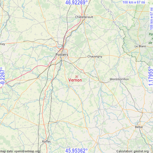
Vernon GPS coordinates[2]
46° 26' 25.116" North, 0° 28' 35.148" East
| Map corner | latitude | longitude |
|---|---|---|
| Upper-left | 46.92269°, | -0.2267° |
| Center: | 46.44031°, | 0.47643° |
| Lower-right: | 45.95362°, | 1.17955° |
| Map W x H: | 107.8×107.7 km | = 67×66.9mi |
| max Lat: | 51.07786° ⇑60.6% North |
| Vernon: | 46.44031° |
| min Lat: | ⇓39.4% South 41.3874° |
| min Long | Vernon | max Long |
| -5.08615° | 0.47643° | 9.52242° |
| W 26.4%⇐ | ⇒73.6% E |
Elevation
Elevation of Vernon is 126 m = 413 ft, and this is 67.7 m = 222 ft below average elevation for this country.
| Max E: |
2333 m = 7654 ft | 51.7% |
| Avg. | 193.7 m = 635 ft | |
| Vernon | 126 m = 413 ft | |
Min E: |
-1 m = -3 ft | 48.3% |
See also: France elevation on elevation.city.
Geographical zone
Vernon is located in North temperate zone (between Tropic of Cancer and the Arctic Circle). Distance of this North polar circle is 2237.5 km =1390.3 mi to North.| Distance of | km | miles | from Vernon |
|---|---|---|---|
| North Pole | 4843.4 | 3009.5 | to North |
| Arctic Circle | 2237.5 | 1390.3 | to North |
| Tropic Cancer | 2557.8 | 1589.3 | to South |
| Equator | 5163.7 | 3208.6 | to South |


Nearby cities:
15 places around Vernon: (largest is in red/bold)
• Aslonnes
11.8 km =7.3 mi,  247°
247°
• Fleuré
5.4 km =3.4 mi,  39°
39°
• La Villedieu-du-Clain
8.4 km =5.2 mi,  281°
281°
• Lhommaizé
9.3 km =5.8 mi,  93°
93°
• Magné
11.3 km =7 mi,  214°
214°
• Marnay
11.4 km =7.1 mi,  244°
244°
• Mignaloux-Beauvoir
12.4 km =7.7 mi,  337°
337°
• Nouaillé-Maupertuis
8.9 km =5.5 mi,  327°
327°
• Roches-Prémarie-Andillé
9.5 km =5.9 mi,  301°
301°
• Saint-Maurice-la-Clouère
8.4 km =5.2 mi,  216°
216°
• Saint-Secondin
12.5 km =7.8 mi,  174°
174°
• Savigny-Lévescault
10.6 km =6.6 mi,  0°
0°
• Smarves
12.5 km =7.8 mi,  309°
309°
• Tercé
10.8 km =6.7 mi, 38°
• Verrières
9.4 km =5.8 mi,  109°
109°
Sources, notices
• [Note1] Compared only with cities in France existing in our database
• [Src1] Map data: © OpenStreetMap contributors (CC-BY-SA)
• [Src2] Other city data from geonames.org with taken over terms of usage.
• [Src3] Geographical zone / Annual Mean Temperature by Robert A. Rohde @ Wikipedia
