Saint-Maurice-la-Clouère geodata
Saint-Maurice-la-Clouère (Nouvelle-Aquitaine) is a populated place; located in France in Europe/Paris (GMT+2) time zone. With population of 1,081 people, there are 8251 cities with bigger population in this country. Compared to other cities in France, 61.3% of cities are located further ↑North; 74.2% of cities are located further →East and 54.8% of cities have higher elevation than Saint-Maurice-la-Clouère. Note1
Administrative division(s):
- Level 1: Nouvelle-Aquitaine
- Level 2: Vienne
- Level 3: Arrondissement de Montmorillon
- Level 4: Saint-Maurice-la-Clouère
Current local time in Saint-Maurice-la-Clouère:
10:43 AM, SaturdayDifference from your time zone: hours


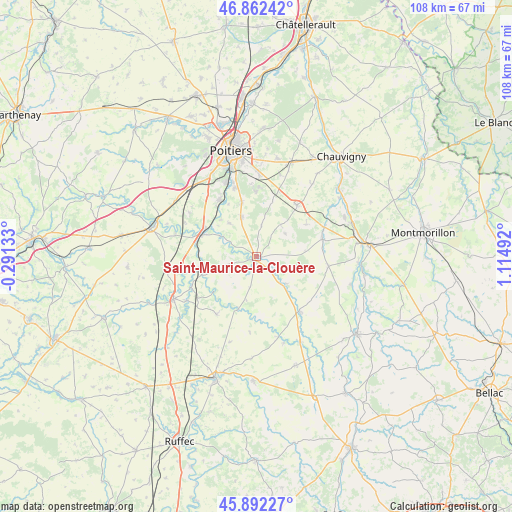
Saint-Maurice-la-Clouère GPS coordinates[2]
46° 22' 46.2" North, 0° 24' 42.48" East
| Map corner | latitude | longitude |
|---|---|---|
| Upper-left | 46.86242°, | -0.29133° |
| Center: | 46.3795°, | 0.4118° |
| Lower-right: | 45.89227°, | 1.11492° |
| Map W x H: | 107.9×107.9 km | = 67×67mi |
| max Lat: | 51.07786° ⇑61.3% North |
| Saint-Maurice-la-Clouère: | 46.3795° |
| min Lat: | ⇓38.7% South 41.3874° |
| min Long | Saint-Maurice-l | max Long |
| -5.08615° | 0.4118° | 9.52242° |
| W 25.8%⇐ | ⇒74.2% E |
Elevation
Elevation of Saint-Maurice-la-Clouère is 117 m = 384 ft, and this is 76.7 m = 252 ft below average elevation for this country.
| Max E: |
2333 m = 7654 ft | 54.8% |
| Avg. | 193.7 m = 635 ft | |
| Saint-Maurice-la-Clouère | 117 m = 384 ft | |
Min E: |
-1 m = -3 ft | 45.2% |
See also: France elevation on elevation.city.
Geographical zone
Saint-Maurice-la-Clouère is located in North temperate zone (between Tropic of Cancer and the Arctic Circle). Distance of this North polar circle is 2244.3 km =1394.5 mi to North.| Distance of | km | miles | from Saint-Maurice-la-Clouère |
|---|---|---|---|
| North Pole | 4850.1 | 3013.7 | to North |
| Arctic Circle | 2244.3 | 1394.5 | to North |
| Tropic Cancer | 2551 | 1585.1 | to South |
| Equator | 5156.9 | 3204.3 | to South |


Nearby cities:
15 places around Saint-Maurice-la-Clouère: (largest is in red/bold)
• Aslonnes
6.4 km =4 mi,  290°
290°
• Champagné-Saint-Hilaire
9.5 km =5.9 mi,  225°
225°
• Château-Garnier
13.5 km =8.4 mi,  175°
175°
• Château-Larcher
8.6 km =5.3 mi,  299°
299°
• Fleuré
13.8 km =8.6 mi,  37°
37°
• La Villedieu-du-Clain
9 km =5.6 mi,  339°
339°
• Magné
2.9 km =1.8 mi,  209°
209°
• Marnay
5.7 km =3.5 mi, 288°
• Nouaillé-Maupertuis
14.3 km =8.9 mi,  0°
0°
• Roches-Prémarie-Andillé
12.1 km =7.5 mi, 344°
• Saint-Secondin
8.4 km =5.2 mi,  132°
132°
• Sommières-du-Clain
11.8 km =7.3 mi,  200°
200°
• Vernon
8.4 km =5.2 mi, 36°
• Verrières
14.3 km =8.9 mi,  75°
75°
• Vivonne
12.6 km =7.8 mi, 296°
Sources, notices
• [Note1] Compared only with cities in France existing in our database
• [Src1] Map data: © OpenStreetMap contributors (CC-BY-SA)
• [Src2] Other city data from geonames.org with taken over terms of usage.
• [Src3] Geographical zone / Annual Mean Temperature by Robert A. Rohde @ Wikipedia
