Saint-Secondin geodata
Saint-Secondin (Nouvelle-Aquitaine) is a populated place; located in France in Europe/Paris (GMT+2) time zone. With population of 558 people, there are 14045 cities with bigger population in this country. Compared to other cities in France, 61.9% of cities are located further ↑North; 73.5% of cities are located further →East and 51.1% of cities have lower elevation than Saint-Secondin. Note1
Administrative division(s):
- Level 1: Nouvelle-Aquitaine
- Level 2: Vienne
- Level 3: Arrondissement de Montmorillon
- Level 4: Saint-Secondin


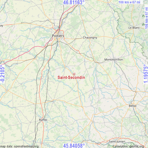
Saint-Secondin GPS coordinates[2]
46° 19' 41.736" North, 0° 29' 33.468" East
| Map corner | latitude | longitude |
|---|---|---|
| Upper-left | 46.81163°, | -0.2105° |
| Center: | 46.32826°, | 0.49263° |
| Lower-right: | 45.84058°, | 1.19575° |
| Map W x H: | 108×108 km | = 67.1×67.1mi |
| max Lat: | 51.07786° ⇑61.9% North |
| Saint-Secondin: | 46.32826° |
| min Lat: | ⇓38.1% South 41.3874° |
| min Long | Saint-Secondin | max Long |
| -5.08615° | 0.49263° | 9.52242° |
| W 26.5%⇐ | ⇒73.5% E |
Elevation
Elevation of Saint-Secondin is 136 m = 446 ft, and this is 57.7 m = 189 ft below average elevation for this country.
| Max E: |
2333 m = 7654 ft | 48.9% |
| Avg. | 193.7 m = 635 ft | |
| Saint-Secondin | 136 m = 446 ft | |
Min E: |
-1 m = -3 ft | 51.1% |
See also: France elevation on elevation.city.
Geographical zone
Saint-Secondin is located in North temperate zone (between Tropic of Cancer and the Arctic Circle). Distance of this North polar circle is 2250 km =1398.1 mi to North.| Distance of | km | miles | from Saint-Secondin |
|---|---|---|---|
| North Pole | 4855.8 | 3017.3 | to North |
| Arctic Circle | 2250 | 1398.1 | to North |
| Tropic Cancer | 2545.3 | 1581.6 | to South |
| Equator | 5151.2 | 3200.8 | to South |


Nearby cities:
15 places around Saint-Secondin: (largest is in red/bold)
• Aslonnes
14.6 km =9.1 mi,  303°
303°
• Bouresse
9.6 km =6 mi,  66°
66°
• Champagné-Saint-Hilaire
12.9 km =8 mi,  265°
265°
• Château-Garnier
9.3 km =5.8 mi,  213°
213°
• Gouex
15.8 km =9.8 mi, 74°
• Lhommaizé
14.4 km =8.9 mi,  34°
34°
• Magné
8.3 km =5.2 mi,  292°
292°
• Marnay
13.8 km =8.6 mi, 303°
• Payroux
12.7 km =7.9 mi,  183°
183°
• Queaux
13.4 km =8.3 mi,  90°
90°
• Saint-Maurice-la-Clouère
8.4 km =5.2 mi,  312°
312°
• Sommières-du-Clain
11.6 km =7.2 mi,  242°
242°
• Usson-du-Poitou
6.2 km =3.9 mi,  154°
154°
• Vernon
12.5 km =7.8 mi,  354°
354°
• Verrières
12.1 km =7.5 mi,  39°
39°
Sources, notices
• [Note1] Compared only with cities in France existing in our database
• [Src1] Map data: © OpenStreetMap contributors (CC-BY-SA)
• [Src2] Other city data from geonames.org with taken over terms of usage.
• [Src3] Geographical zone / Annual Mean Temperature by Robert A. Rohde @ Wikipedia
